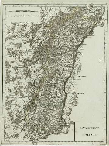
Gouvernement d'Alsace : [carte]


Section: Maps, plans and nautical charts
Uniform title: Alsacia (Francia). Mapas generales. 1:488400 (179)
Title: Gouvernement d'Alsace : [carte] / gravé par P.F. Tardieu ; ecrit par Dubuisson
Material or type of resouce Area: [Ca. 1:488.400]
Publication: Paris : Chez Mr. Mentelle..., Rue de Seine Fauxbourg S. Germain..., [1797?]
Physical description: 1 mapa : col. ; 49 x 34 cm
Content type: Imagen cartográfica
Media type: computadora
Carrier type: recurso en línea
Notes: Escala gráfica de 10 Lieues communes de 25 au Degré [= 9,1 cm], además en "Grandes lieues de 20 au Degré". Coordenadas referidas a los meridianos de París y de Hierro (E 4 05'-E 6 04'/N 49 11'-N 47 02')
Relieve representado mediante signos morfográficos
Márgenes graduados. - Relieve representado por sombreado. - Red de transportes.- Divisiones administrativas delimitadas por línea de color. - Representación esquemática de la vegetación. - Toponímia
Copia digital. España : Ministerio de Cultura. Dirección General del Libro, Archivos y Bibliotecas, 2010
Other titles: En: Atlas nouveau. - Paris : Chez Mr. Mentelle Historiographe de Monseigneur le Comte d'Antois, Rue de Seine Fauxbourg S. Germain, Hotel de Mayence, [1797 ?]
Materia / lugar / evento: Mapas generales
Divisiones administrativas
Fronteras
Carreteras
Redes de transporte
Topónimos antiguos
Francia
Other authors: Dubuisson, 17..-18
Tardieu, Antoine-François, 1757-1822
Mentelle, Edmé, 1730-1815
UDC: 912:[341.222+625.7](44-2/-5)'1797'
44 Alsacia
Type of publication:
 Maps
Maps
Rights:
Préstamo:
 Disponible
