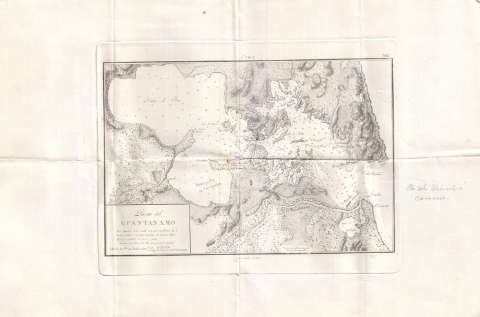
Puerto del Guantánamo


Section: Maps, plans and nautical charts
Title: Puerto del Guantánamo
Edición: ed. corr.
Material or type of resouce Area: Escala [ca. 1:61.898]. 1 milla [= 2,6 cm]
Publication: [Lugar de publicación no identificado] : [Editor no identificado], 1881
Physical description: 1 carta naútica : col. ; 21 x 31 cm en h. de 35 x 52 cm
Content type: Imagen cartográfica
Media type: computadora
Carrier type: recurso en línea
Notes: Coordenadas referidas al meridiano de San Fernando
Relieve por normales
Indica sondas batimétricas
Clave alfabética para determinar la calidad del fondo
Indica las coordenadas de la Puerta de Barlovento
Señala en color amarillo y rojo los faros
En la parte superior: "Cuba" y el número "285"
En la margen derecho nota a lapiz: "Pta del Uicaedo Caracoles"
Sello en seco de la Dirección de Hidrografía
Materia / lugar / evento: Cartas náuticas
Puertos
Costas
Perspectivas de costas
Bahías
Batimetría
Guantánamo
Cuba
UDC: (729.1 Guantanamo)
Type of publication:
 Maps
Maps
Rights:
Préstamo:
 Disponible
