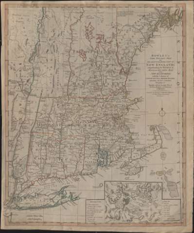
Bowles's New Pocket Map of the Most Inhabited Part of New...


 Maps, plans and nautical charts
Bowles's New Pocket Map of the Most Inhabited Part of New England : comprehending the Provinces of Massachusets Bay... (1783?)
Maps, plans and nautical charts
Bowles's New Pocket Map of the Most Inhabited Part of New England : comprehending the Provinces of Massachusets Bay... (1783?)
 Disponible Holdings
 Section: Maps, plans and nautical charts
Uniform title: Nueva Inglaterra. Divisiones administrativas. 1783?. 1:740.000
Title: Bowles's New Pocket Map of the Most Inhabited Part of New England : comprehending the Provinces of Massachusets Bay and New Hampshire, with the Colonies of Connecticut & Rhode Island, Divided into their Counties Townships, &c. together with an accurate plan of the town, harbour and environs of Boston
Material or type of resouce Area: Escala [ca. 1:740.000]. 6 english marine leagues 20 to a Degree [= 4,5 cm] ( (O 56º30'-O 51º30'/N 44º30'-N 40º30')
Publication: London : Carrington Bowles, [1783?]
Physical description: 1 mapa : grab. ; 64 x 52 cm
Content type: Imagen cartográfica
Media type: computadora
Carrier type: recurso en línea
Notes: Escala también expresada en "20 english miles 69 1/2 to a Degree" [= 4 cm]
Fecha de publicación tomada del atlas para el que se realizó este mapa, según consta en: "Tooley's Dictionary of Mapmakers", T. I, p. 179
Orientado con lis en cuadrante y círculo
Meridianos de origen: Ferro y Londres. Red geográfica de 30' en 30'
Relieve por montes de perfil
Divisiones administrativas diferenciadas por color
Inserta: "Plan of Boston with its Harbour and Environs".- Escala [ca. 1:70.000]. 2 miles [= 4'8 cm]
Materia / lugar / evento: Colonias
Divisiones administrativas
Nueva Inglaterra
Massachusetts
New Hampshire
Connecticut
Rhode Island
Estados Unidos
Other authors: Bowles, Carrington, 1724-1793
UDC: 912:325.2/.4(73-18)"17"
(73-18)
Type of publication:
Maps
Rights:
Préstamo:
Disponible
