The East Indies, with the roads


 Maps, plans and nautical charts
The East Indies, with the roads (30th. Apr. 1768)
- Jefferys, Thomas, ca. 1710-1771
Maps, plans and nautical charts
The East Indies, with the roads (30th. Apr. 1768)
- Jefferys, Thomas, ca. 1710-1771
 Disponible Holdings
 Section: Maps, plans and nautical charts
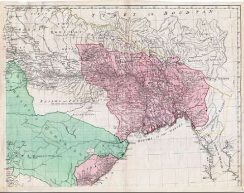
Title: The East Indies, with the roads / by Thomas Jefferys, Geographer to the King
Author: Jefferys, Thomas, ca. 1710-1771
[The East Indies, with the roads] All editions
Characteristics of the edition: 1768. 1:2595000. Inglés
Edición: end ed.
Material or type of resouce Area: Escala [ca. 1:2.595.000]
Publication: London : Published according to Act of Parliament by Robt. Sayer, n° 53 in Fleet Street, 30th. Apr. 1768
Physical description: 1 mapa en 4 h. : col. ; 108 x 139 cm, en h. de 56 x 72 cm
Content type: Imagen cartográfica
Media type: computadora
Carrier type: recurso en línea
Notes: Comprende la península del Indostán, Birmania y el Sur del Tibet
Dedicatoria: "To the Directors of the Honble. East India Company"
Escalas gráficas de 200 millas estatutarias [= 12'4 cm], 80 leguas de 30 en grado, 60 leguas marinas de 20 en grado, 100 "Jeribi" y 120 "Rifmi". Coordenadas referidas a los meridianos de Hierro (E 76°20--E 113°40'/N 29°40'--N 5°30') y París (E 58°50'--E 96°00'). Red geográfica de 1° en 1°
Orografía de perfil. Indica bajos y veriles
Relación de las distintas soberanías en que está dividida la península del Indostán, indicadas por clave numérica
Reproducción digital
Genre / form: Documentos archivísticos
Mapas generales
Other authors: Sayer, Robert, 1725-1794
España. Dirección de Hidrografía. Expediciones a Indias, productor
Museo Naval (Madrid). Archivo. Documentos gráficos, Mapas
Type of publication:
Maps
Rights:
Préstamo:
Disponible
