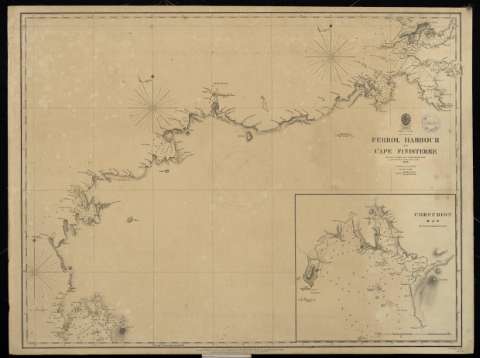
Spain West Coast. Ferrol harbour to cape Finisterre


 Disponible Holdings
 Section: Maps, plans and nautical charts
Uniform title: España (costa NO.). Cartas náuticas. 1836 (1846). Español. Escala [ca. 1:1.161.030]
Title: Spain West Coast. Ferrol harbour to cape Finisterre / by Don I. F. Flórez Capt. in the Spanish Navy 1836 ; J. & C. Walker Sculp
Material or type of resouce Area: Escala [ca. 1:1.161.030]
Publication: London : Published according to Act of Parliament at the Hydrographic Office of the Admiralty, 1846
Physical description: 1 carta náutica : papel entelado ; 47 x 62 cm
Content type: Imagen cartográfica
Media type: computadora
Carrier type: recurso en línea
Notes: Corrections to 1861. Nov. 62. May 65
Meridiano de Greenwich
Sello: Hydrographic Office
Nº H. O.: 1755
Contains: Inserta
Corcubion bay / by Ignacio Fernández Flórez.- Escala gráfica de 10 cables y 3 millas [10 cm].- 1 plano ; 21 X 23 cm
Genre / form: Cartas náuticas
Other authors: España. Dirección de Hidrografía, productor
Type of publication:
 Maps
Maps
Préstamo:
Disponible
