[Itinerario topográfico] de Villamayor á Almodovar del Campo


 Maps, plans and nautical charts
[Itinerario topográfico] de Villamayor á Almodovar del Campo (1883)
Maps, plans and nautical charts
[Itinerario topográfico] de Villamayor á Almodovar del Campo (1883)
 Disponible Holdings
 Section: Maps, plans and nautical charts
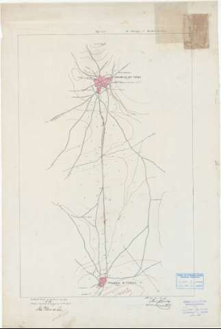
Title: [Itinerario topográfico] de Villamayor á Almodovar del Campo / el cap. de E. M. José Pineda
Material or type of resouce Area: Escala 1:20.000
Publication: 1883
Physical description: 1 mapa : ms., col., tela para planos ; 74'6 x 50'0 cm
Content type: Imagen cartográfica
Media type: computadora
Carrier type: recurso en línea
Notes: Comprende parte de los términos municipales de Villamayor de Calatrava y Almodóvar del Campo, en la provincia de Ciudad Real
Título completado a partir del contenido del documento, habiéndose añadido: "Itinerario topográfico"
Firmadas y rubricadas por los autores
Figura la firma de conformidad del Teniente Coronel, Comante en Jefe de los trabajos, Francisco Ponce de León: fechada en: "Ciudad-Real 10 de junio de 1883"
Orientadas al norte magnético
Orografía por curvas de configuración croquisadas sin cotas
Mención del número de vecinos de los núcleos de población más significativos
Relacionado con la memoria de sign. C-41 N°. 7
Materia / lugar / evento: Itinerarios topográficos
1883
Almodóvar del Campo
Ciudad Real (Provincia)
Other authors: Pineda y Rivero, José
España. Estado Mayor Central
UDC: 912:528.42(464.3)"1883"
464.3 Almodóvar del Campo, Término Municipal
464.3 Villamayor de Calatrava, Término Municipal
Type of publication:
Maps
Rights:
Préstamo:
Disponible
