Itinerario topográfico de Alcalá La Real a Jaén por...


 Maps, plans and nautical charts
Itinerario topográfico de Alcalá La Real a Jaén por Alcaudete (1852)
Maps, plans and nautical charts
Itinerario topográfico de Alcalá La Real a Jaén por Alcaudete (1852)
 Disponible Holdings
 Section: Maps, plans and nautical charts
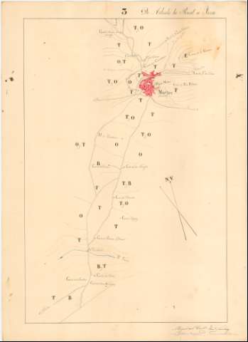
Title: Itinerario topográfico de Alcalá La Real a Jaén por Alcaudete / ejecutado por los Capitanes del Cuerpo de E.M, Miguel Trell y Chacón y Francisco Sanchez
Material or type of resouce Area: Escala 1:20.000
Publication: 1852
Physical description: 1 mapa en 4 h. : ms., col. ; en h. de 70 x 50,8 cm.
Content type: Imagen cartográfica
Media type: computadora
Carrier type: recurso en línea
Notes: Comprende parte de los partidos judiciales de Alcalá La Real, Martos y Jaén en la provincia de este nombre, pasando, entre otras, por las poblaciones de Castillo de Locubín y Torre del Campo
Título y mención de responsabilidad tomados de la hoja que agrupa a las que conforman este itinerario
Manuscritos firmados y rubricados por los autores
Orientado con flecha
Relieve representado por curvas de nivel
Mención del número de vecinos de los núcleos de población más significativos
Se corresponde con la memoria de sign. C-44 N° 2
Other titles: Documento relacionado: Trell y Chacón, Miguel del. Itinerario de Alcalá la Real a Jaén por Alcaudete y Martos
Materia / lugar / evento: Itinerarios topográficos
Núcleos de población
Cultivos
Alcaudete
Jaén (Provincia)
Jaén
Other authors: Trell y Chacón, Miguel del, 1823-1883
Sánchez, Francisco Militar
España. Estado Mayor Central
UDC: (460.352 Alcalá la Real)
Type of publication:
Maps
Rights:
Préstamo:
Disponible
