[Itinerario topográfico de la línea de ferrocarril] de...


 Maps, plans and nautical charts
[Itinerario topográfico de la línea de ferrocarril] de Alcázar de Sn. Juan a Córdoba (s.XIX)
Maps, plans and nautical charts
[Itinerario topográfico de la línea de ferrocarril] de Alcázar de Sn. Juan a Córdoba (s.XIX)
 Disponible Holdings
 Section: Maps, plans and nautical charts
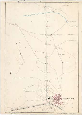
Title: [Itinerario topográfico de la línea de ferrocarril] de Alcázar de Sn. Juan a Córdoba / el Comandante de Caba. Capitan de E.M. Adofo Rodriguez, el Teniente de E.M. Alejandro Iriarte
Material or type of resouce Area: Escala [1:20.000]
Publication: [s.XIX]
Physical description: 1 mapa en 25 h. : ms., col. ; 61,7 x 43,2 cm o menor
Content type: Imagen cartográfica
Media type: computadora
Carrier type: recurso en línea
Notes: Comprende la parte oriental de la provincia de Ciudad Real, la noroccidental de Jaen, y la occidental de Córdoba, pasando entre otras, por las poblaciones de Manzanares, Valdepeñas, Santa Cruz de Mudela, Villanueva de la Reina, Andújar, Villa del Rio, Pedro Abad y Carpio
Título completado a partir del contenido del documento, habiéndose añadido: "Itinerario topográfico de la línea de ferrocarril"
Firmadas y rubricadas por los autores
Orientadas al norte geográfico y magnético
Orografía por curvas de configuración croquisadas sin cotas
Longitud total de la línea ferroviaria: 290 km
Mención del número de habitantes de los núcleos de población más significativos
Materia / lugar / evento: Itinerarios topográficos
Líneas ferroviarias
Jaén (Provincia)
Córdoba (Provincia)
Córdoba
Ciudad Real (Provincia)
Other authors: Rodríguez y Bruzón, Adolfo, 1840-1916
Iriarte, Alejandro
España. Estado Mayor Central
UDC: 912:528.42.625.12(464.3-11)(468.14-18)(468.13-15)"18"
464.3-11
468.14-18
468.13-15
Type of publication:
Maps
Rights:
Préstamo:
Disponible
