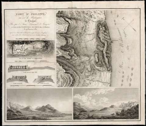
Fort St. Philippe au col de Balaguer en Catalogne : Pris...


 Maps, plans and nautical charts
Fort St. Philippe au col de Balaguer en Catalogne : Pris par l'Armée Françóise d'Aragon aux Ordres de SGE le... (181-)
Maps, plans and nautical charts
Fort St. Philippe au col de Balaguer en Catalogne : Pris par l'Armée Françóise d'Aragon aux Ordres de SGE le... (181-)
 Disponible Holdings
 Section: Maps, plans and nautical charts
Title: Fort St. Philippe au col de Balaguer en Catalogne : Pris par l'Armée Françóise d'Aragon aux Ordres de SGE le Maréchal Suchet Duc d'Albufera le 9 Janvier 1811, reprís le 7 Juin 1813, et détruit le 19 por l'armée Angloise aux ordres du Lieutenant Géneral Sr. John Murray / Gravé por E. Collin Rue de la Harpe, No. 45
Material or type of resouce Area: Escala [ca. 1:18.000]. 1.000 toesas [=10,6 cm]
Publication: [Francia : [Editor no identificado], 181-]
Physical description: 1 mapa : montado sobre tela ; 41 x 49 cm
Content type: Imagen cartográfica
Media type: computadora
Carrier type: recurso en línea
Notes: Comprende la zona del puerto de Balaguer con el castillo de San Felipe, en el término municipal de Vandellós (Tarragona)
Orientado con cuadrante
Relieve representado por normales
Indica las posiciones ocupadas por una parte de las tropas inglesas
Incluye: "Plan du fort St. Philippe". Escala [ca. 1:1.300]. 75 toesas [= 11,4 cm] ; "Profils du Port Saint Philippe". Escala [ca. 1.600]. 50 toesa [= 14,8 cm]. Consta de dos perfiles transversales y uno longitudinal ; "Vue prise du côté de Tortose" ; "Vue prise du côté de Tarragone"
Materia / lugar / evento: Fortificaciones
Mapas generales
Edificios militares
Perfiles
Perspectivas
Guerras de independencia
1811
1813
Vandellós
Tarragona (Provincia)
Cataluña
España
España - Historia - 1808-1814 (Guerra de la Independencia)
Other authors: Collin, Etienne
UDC: 912:742(084.3)]:623.6:623.1:744.4)(467.141.4)"1811/1813"
467.141.4 Balaguer, Puerto
467.141.4 Vandellós, Término Municipal
Type of publication:
Maps
Rights:
Préstamo:
Disponible
