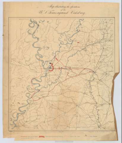
Map illustrating the operations of the U.S. Forces...


 Maps, plans and nautical charts
Map illustrating the operations of the U.S. Forces against Vicksburg (1863-1900)
Maps, plans and nautical charts
Map illustrating the operations of the U.S. Forces against Vicksburg (1863-1900)
 Disponible Holdings
 Section: Maps, plans and nautical charts
Title: Map illustrating the operations of the U.S. Forces against Vicksburg / compiled at the U.S. Coast survey office ; J.W. Maedel
Material or type of resouce Area: Escala [ca. 1:386244], 30 statute miles [= 12'5 cm]
Publication: [Washington] : U.S. coast survey office, [1863-1900]
Physical description: 1 mapa : col. ; 54 x 46 cm
Content type: Imagen cartográfica
Media type: computadora
Carrier type: recurso en línea
Notes: Comprende la parte suroccidental del estado de Mississippi y la nororiental del de Luisiana, en los Estados Unidos
Fechas de publicación y contenido deducidas a partir del contenido del documento
Tabla de signos convencionales para indicar, entre otros, el asedio a Vicksburg, las rutas de los Generales Grant y Blais, y las victorias del ejéricto federal
Materia / lugar / evento: Guerras
Sitios
Batalla de Vicksburg
1863
Luisiana (Estados Unidos, Estado)
Vicksburg
Estados Unidos
Other authors: Maedel, J.W
Estados Unidos. Coast Survey
UDC: 762-14
763-18
762 Vicksburg
Type of publication:
Maps
Rights:
Préstamo:
Disponible
