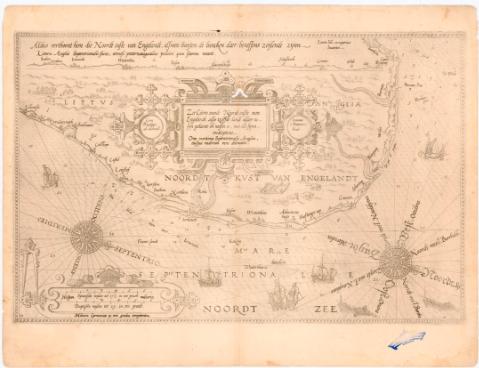
Zee Caerte vande Noordt Custe van Engelandt alsoe...


 Maps, plans and nautical charts
Zee Caerte vande Noordt Custe van Engelandt alsoe tzelssde landt aldaer in snn gedaente én neseu is, met alle Synn... (1584-1585)
Maps, plans and nautical charts
Zee Caerte vande Noordt Custe van Engelandt alsoe tzelssde landt aldaer in snn gedaente én neseu is, met alle Synn... (1584-1585)
 Disponible Holdings
 Section: Maps, plans and nautical charts
Title: Zee Caerte vande Noordt Custe van Engelandt alsoe tzelssde landt aldaer in snn gedaente én neseu is, met alle Synn Undreptenn Oral maritimae Septentrionalis Anglial enisque vadorum vera delineatio / Lucas Ises aurigarius Invéntor ; Io - annes á Doetecum Fecit
Material or type of resouce Area: Escala [ca. 1:390000], 6 Spaeusche mulen to 17 1/2 in cen graedt miliaria [= 9'5 cm]
Publication: [Holanda ? : s.n., 1584-1585]
Physical description: 1 carta nautica ; 33x53 cm en h. de 41x54'5 cm
Notes: Presenta además 1 perfil
Pertenece al Atlas 'Sphrengle der Zeevér'. - 1584-1585. - 24
Escalas graficas de '6 Duntche mnlen tot 15 in cen graedt' [= 11 cm] Orientado con lis en rosa de 32 vientos prolongados
Relieve de perfil y sondas batimétricas
Indice veriles bajos, fondeaderos
Leyenda explicativa al verso
Titulo enmarcado en cartela Renacentista de igual que la escala
Representación de 5 galeras en el mar
Procede de la 'Colección Rico y Sinobas'
Other authors: Waghenaer, Lucas Jansz (ca. 1533-1606)
Doetecum, Jan van
UDC: 912:[551.46:551.468](410-328 Norfolk)'1584/1585'
Type of publication:
Maps
Rights:
Préstamo:
Disponible
