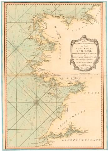
New Hydrographical Survey of the west Coast of Ireland,...


 Maps, plans and nautical charts
New Hydrographical Survey of the west Coast of Ireland, A] : from the Shannon mouth to Wrris Head with part of the... (1786)
Maps, plans and nautical charts
New Hydrographical Survey of the west Coast of Ireland, A] : from the Shannon mouth to Wrris Head with part of the... (1786)
 Disponible Holdings
 Section: Maps, plans and nautical charts
Title: New Hydrographical Survey of the west Coast of Ireland, A] : from the Shannon mouth to Wrris Head with part of the North Coast from Urris Head to Milkhaven being a continuation of the Marine surveys / made by Capt. Joseph Huddart
Material or type of resouce Area: Escala [ca. 1:300000], 8 Nautic leag. 20 to a Degree [= 13 cm]
Publication: London : Printed for R. Jayer Printseller, Fleet street, 1786
Physical description: 1 carta nautica : col. ; 77x56 cm, pleg. en 39x56,5 cm
Notes: Coordenadas referidas a un meridiano que no se especifica, latitud (N54°27'-N52°15'). Recuadro geográfico de 5° en 5°. Orientado con lis en rosa de 10 vientos prolongados
Relieve de perfil sondas batimétricas
Indica veriles, bajos y fondeaderos. Dirección de la marea con flecha
Título enmarcado en cartela con motivos florales
Materia / lugar / evento: Cartas náuticas
Costas
1786
Milk Haven
Shannon (Río)
Other authors: Huddart, Joseph
Sayer, Robert, 1725-1794
UDC: 912:[551.46:551.468](410-328 Irlanda del Norte)'1786'
del Norte)
(410 Milk Haven)
(410 Shannon Mouth)
Type of publication:
Maps
Rights:
Préstamo:
Disponible
