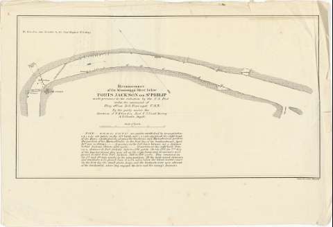
Reconnoissance of the Mississippi River below Forts...


 Maps, plans and nautical charts
Reconnoissance of the Mississippi River below Forts Jackson and St. Philip : made previous to the reduction by the... (1862?)
Maps, plans and nautical charts
Reconnoissance of the Mississippi River below Forts Jackson and St. Philip : made previous to the reduction by the... (1862?)
 Disponible Holdings
 Section: Maps, plans and nautical charts
Title: Reconnoissance of the Mississippi River below Forts Jackson and St. Philip : made previous to the reduction by the U.S. Fleet under the command of Flag Officer D.G. Farragut, U.S.N. [Mapa] / By the party under the direction of F.H. Gerdes, Asst. U.S. Coast Survey ; A.D. Bache, Supdt
Material or type of resouce Area: Escala [ca. 1:41000]
Publication: Philada [i.e. Philadelphia] : Bowen & Co. Lith., [1862?]
Physical description: 1 map. ; 23 x 42 cm
Notes: Representación de la parte del río en que están situados ambos fuertes con indicación del radio de alcance defensivo de las casamatas del primero de ellos
Fecha de publicación tomada del "Indice de mapas y planos históricos de América" del SGE, 1979
Escala gráfica de 4000 yardas. [= 9 cm]. Orientado con flecha
Con una nota en la que se detalla la ubicación del armamento perteneciente a la Mortar Flotilla, localizada en el plano por clave alfanumérica
Materia / lugar / evento: Operaciones bélicas
Estrategia militar
Fortificaciones
S.XIX
Fort Saint Phillip
Luisiana (Estados Unidos, Estado)
Fort Jackson
Other authors: Gerdes, F.H
Bache, A. D, 1806-1867
Bowen & Co. (Philadelphia)
UDC: 912:355.4:355.43:623.1(282.272.7.05)"1862"
282.272.7.05
Type of publication:
Maps
Rights:
Préstamo:
Disponible
