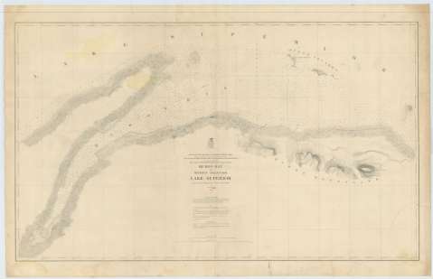
Huron Bay and Huron Islands : Lake Superior


 Disponible Holdings
 Section: Maps, plans and nautical charts
Title: Huron Bay and Huron Islands : Lake Superior / Projected from a Trigonometrical Survey made in 1866 and Published in 1869, Made in obedience, to acts of Congress and orders from the Headquarters of the corps of Engineers War Department, and under the direction of Brut. Brig. Genl. W.F. Raynolds, t. Col. Corps of Engrs.
Material or type of resouce Area: Escala 1:30000 (O 88°17'30''--O 87°51'45''/N 46°59'15''--N 46°48'45'')
Publication: [Washington] : Corps of Engineers. War Department, 1869
Physical description: 1 carta náutica ; 65 x 110 cm
Content type: Imagen cartográfica
Media type: computadora
Carrier type: recurso en línea
Series: (Survey of the Northern and North Western Lakes)
Notes: Escala también dada en formas gráficas de 3000 yardas y 3 millas legales. Orientado con nudo de treintaidos rumbos
Relieve por normales
Indica sondas batimétricas y veriles, así como las distintas líneas de derrota a seguir para arribar a la bahía
Clave hidrográfica para determinar la calidad del fondo
En nota se señalan todos aquellos trabajos tenidos en cuenta para la elaboración del presente documento
Materia / lugar / evento: Cartas náuticas
Batimetría
Bahías
Islas
1866
1869
Hurón (Islas)
Other authors: Raynolds, W. F
Estados Unidos. Army. Corps of Engineers
UDC: 774-16
Type of publication:
 Maps
Maps
Rights:
Préstamo:
Disponible
