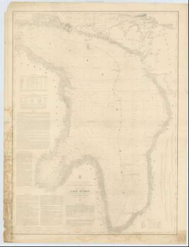
General Chart of Lake Huron


Section: Maps, plans and nautical charts
Title: General Chart of Lake Huron / Projected from trigonometrical Surveys under the orders of Captain G.G. Meade Topl. Engrs. and from other reliable information 1860 ; Made in obedience, to actas of Congress and under the direction of the Bureau of Topographical Engineers of the War Department ; Reduction for Engraving by J.U. Müeller Assistant U.S.L.S ; Engraved by W.H. Dougal
Material or type of resouce Area: Escala 1:400000 (O 84°25'--O 81°10'/ N 46°05'--N 42°55')
Publication: [Washington] : Bureau of Topographical Engineers of the War Department, 1860
Physical description: 1 carta náutica ; 89 x 67 cm
Content type: Imagen cartográfica
Media type: computadora
Carrier type: recurso en línea
Series: (Survey of the Northern and North Western Lakes)
Notes: Escala también dada en formas gráficas de 60000 yardas y 30 millas legales. Orientado con tres nudos de treintaidos rumbos
Relieve por normales
Indica sondas batimétricas, veriles y faros, así como las distintas líneas de derrota a seguir para navegar por el lago
Clave hidrográfica para determinar la calidad del fondo
Indica los límites fronterizos entre los dos paises a los que pertenece el lago Huron
Tablas que informans, por un lado de las características de los faros, por otro de la variación interanual del nivel del mar, y además del grado de declinación magnética
En nota se explica la naturaleza y carácter de los puertos del mismo lago
Inserta: [Theree profiles of the cities Blackriver, Stallord and Presque Isle]. Escala indeterminada
Materia / lugar / evento: Cartas náuticas
Batimetría
Topografía
Perfiles
Divisiones administrativas
Lagos
Ríos
1860
Hurón (Canadá)
Canadá
Black
Estados Unidos
Maine (Estados Unidos)
Míchigan
Presque Isle
Other authors: Meade, George G
Dougal, W. H
Mueller, J. U
Estados Unidos. War Department. Engineer Bureau
UDC: 774-11
713-12
774 Black River
774 Presque Isle
Type of publication:
 Maps
Maps
Rights:
Préstamo:
 Disponible
