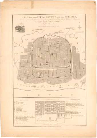
Plan of the city of Canton and its Suburbs < A :...


 Maps, plans and nautical charts
Plan of the city of Canton and its Suburbs < A : Sheuring the principal Streets and some of the conspicuons... (1840)
Maps, plans and nautical charts
Plan of the city of Canton and its Suburbs < A : Sheuring the principal Streets and some of the conspicuons... (1840)
 Disponible Holdings
 Section: Maps, plans and nautical charts
Uniform title: CANTON (China). Planos de población (1840). 1:10000
Title: Plan of the city of Canton and its Suburbs < A : Sheuring the principal Streets and some of the conspicuons buildings from a Chinese survey an an enlarged scale with additions and references / by W. Bramston late of her Majesty's superintendents' Office at Canton ; engraved by James Wyld
Material or type of resouce Area: Escala [ca. 1:10000]
Publication: London : published by James Wyld, geographer to the Queen, Charing Gross East, 1840
Physical description: 1 plano ; 63,2x41,3 cm en h. de 77,4x54,5 cm
Content type: Imagen cartográfica
Media type: computadora
Carrier type: recurso en línea
Notes: Presenta además una vista de la British Factory
Orientado con flecha en estrella
Relación de los principales edificios civiles, públicos, calles, etc. indicados por clave alfabética y numérica
Indica la dirección del rio Sikiang con flecha
Inserta : Foreign Factories. - Escala [ca. 1:2000]
Other authors: Bramston, W
Wyld, James, 1812-1887
UDC: 912:314(510 Cantón)'1840'(084.3)
(282.25 Sikiang)(510)
Type of publication:
Maps
Rights:
Préstamo:
Disponible
