Itinerario topográfico del ferrocarril de Quintanilla a...


 Maps, plans and nautical charts
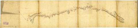
Itinerario topográfico del ferrocarril de Quintanilla a Barruelo (1895)
Maps, plans and nautical charts
Itinerario topográfico del ferrocarril de Quintanilla a Barruelo (1895)
 Disponible Holdings
 Section: Maps, plans and nautical charts
Uniform title: POMAR DE VALDIVIA (Palencia) (Término municipal). Itinerarios topográficos (1895?). 1:10.000
Title: Itinerario topográfico del ferrocarril de Quintanilla a Barruelo / [Cuerpo del Estado Mayor del Ejército]
Material or type of resouce Area: Escala [ca. 1:10000]
Publication: 1895
Physical description: 1 mapa : ms., col., tela para planos ; 34,6 x 175,6 cm
Content type: Imagen cartográfica
Media type: computadora
Carrier type: recurso en línea
Notes: Comprende parte de los términos municipales de Pomar de Valdivia, Aguilar de Campoo y Barruelo de Santullán en la provincia de Palencia pasando, entre otra, por las poblaciones de Qunitanilla de las Torres, Nestor, Villavega y Porquera
Título redactado a partir del contenido del documento
Mención de responsabilidad y fecha tomadas del catálogo del SGE: "Provincias de Soria, Segovia, Avila, Valladolid y Palencia. Siglos XVIII-XIX". 1967, p. 292 bis
Orientado al norte
Orografía por normales
Longitud total del itinerario : 130 km
Indica el radio de las inflexiones de la línea ferroviaria
Anotación en el verso: "Linea de Barruelo"
Other titles: Documento relacionado: Itinerario descriptivo del ferrocarril de Quintanilla de las Torres a Barruelo de Santullán
Materia / lugar / evento: Itinerarios topográficos
Líneas ferroviarias
1895
Aguilar de Campoo
Palencia (Provincia)
Quintanilla de las Torres
Barruelo de Santullán
Other authors: España. Ejército de Tierra. Cuerpo de Estado Mayor
UDC: 912:528.42:625.12(463.214)"1895"
463.214 Pomar de Valdivia, Término Municipal
463.214 Aguilar de Campoo, Término Municipal
463.214 Barruelo de Santullán, Término Municipal
Type of publication:
Maps
Rights:
Préstamo:
Disponible
