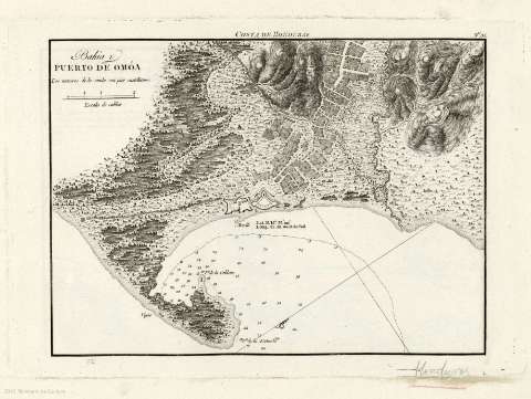
Bahía y puerto de Omóa


 Disponible Holdings
 Section: Maps, plans and nautical charts
Title: Bahía y puerto de Omóa
Author: España. Dirección de Hidrografía
Material or type of resouce Area: Escala [ca. 1:9.496], 2 cables [= 3,9]
Publication: [Madrid] : Dirección de Hidrografía, [1809]
Physical description: 1 carta náutica ; 30 x 21 cm
Content type: Imagen cartográfica
Media type: computadora
Carrier type: recurso en línea
Notes: Presenta la bahía con el plano de la ciudad, el puerto y sus defensas.
Indica coordenadas referidas al meridiano de Cádiz. Orientado con media lis.
Indica relieve representado por sombreado y de perfil.
Indica sondas batimétricas e isolíneas de batimetría.
Señala la profundidad de las sondas en pies castellanos.
Copia digital . España : Ministerio de Cultura y Deporte. Subdirección General de Coordinación Bibliotecaria, 2010
Other titles: En: Portulano de la America Setentrional : dividido en quatro partes. - Madrid : Dirección de Hidrografía, 1809. - Parte segunda. Nº 31
Materia / lugar / evento: Bahías - Mapas
Puertos - Mapas
Caribe (Mar) - Cartas náuticas
Omoa (Honduras, Bahía)
Puerto de Omoa (Honduras)
Related titles: OMOA (Honduras) (Bahía). 1:9496
Type of publication:
 Maps
Maps
Rights:
