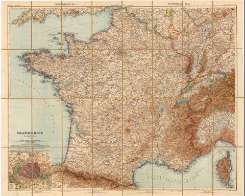
Frankreich in 4 Blattern
Section: Maps, plans and nautical charts
Uniform title: Francia. Mapas generales. 1:1500000 (1904)
Title: Frankreich in 4 Blattern / Von C. Vogel ; Gestochen von H. Eberhardt u W. Weiler ; Berichtigt von H. Kehnert
Material or type of resouce Area: Escala 1:1.500.000
Publication: Gotha : Justus Perthes, 1904
Physical description: 1 mapa : col., montado sobre tela ; 70,5x87,6 cm
Series: (Sonderausgabe aufgezogen in Buchform mit Namenverzeichnis)
Notes: Pertenece al 'Stielers Hand - Atlas'. - n 28
Coordenadas referidas al meridiano de Greenwich (O6°10'-E9°20'/N42°-50°40'). Red geográfica de 1° en 1°
Relieve representado por normales. Isolineas de batrimetria
Tabla de signos convencionales para indicar divisiones administrativas y vias de comunicación
Acompañado de un cuadernillo (97 p.). Encuadernado en tela roja
Inserta : Paris und Umgebung. - Escala 1:150.000
Se dispone de reproducción fotográfica del documento con SG+Ar.H-T.1-C.3-75
Entelado en 32 cuarterones
Materia / lugar / evento: Mapas generales
1904
Other authors: Vogel, C
Eberhardt, H
Stieler, Adolf, 1775-1836
Kehnert, H
Weiler, W
Perthes, Justus, 1749-1816
UDC: 912(44)'1904'
44
Type of publication:
![]() Maps
Maps
Préstamo:
![]() Disponible
Disponible


