Karte von Polen und den angranzenden Provincen in XVI...


 Maps, plans and nautical charts
Karte von Polen und den angranzenden Provincen in XVI Blattern : des H.O.C. Busching Erdbeschreibung und den besten... (1793)
Maps, plans and nautical charts
Karte von Polen und den angranzenden Provincen in XVI Blattern : des H.O.C. Busching Erdbeschreibung und den besten... (1793)
 Disponible Holdings
 Section: Maps, plans and nautical charts
Uniform title: Europa. Mapas generales (1793). 1:1100000
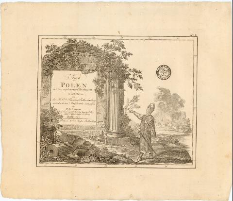
Title: Karte von Polen und den angranzenden Provincen in XVI Blattern : des H.O.C. Busching Erdbeschreibung und den besten Hulfsmitteln entworffen / von D.F. Sotzmann... ; H. Penningh fecit ; C.C. Glassbach sen. fc. ; A.F. Schmidt fc
Material or type of resouce Area: [Ca. 1:1100000], 10 meilen 15 auf ein en Grad [ = 6,5 cm] ; [proyec. cónica]
Publication: Berlin : Verlag der K.P. Ac. Kunft U. buchhandlung, 1793
Physical description: 1 mapa en 16 h. : col. ; h. de 38x46 cm ó menos
Notes: Coordenadas referidas al meridiano de Ferro (E31°50'-E50°40'/N57°15'-N47°30'). Red geográfica de 1° en 1°
Relieve representado por normales
Título enmarcado en ruinas con motivos vegetales y alegorias
Materia / lugar / evento: Mapas generales
Fronteras
Divisiones administrativas
1793
Polonia
Alemania
Lituania
Rusia
República Checa
Other authors: Sotzmann, Daniel Friedrich
Glassbach, Carl Christian
Penningh, H
UDC: 912:341.222(4-11)'1793'
(438)
(430-18)
(474.5)
(47-15)
(437)
Type of publication:
Maps
Rights:
Préstamo:
Disponible
