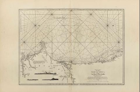
A Chart of the Coast of Africa : Between Cape Blanco and...


 Maps, plans and nautical charts
A Chart of the Coast of Africa : Between Cape Blanco and River Gambia (1781)
Maps, plans and nautical charts
A Chart of the Coast of Africa : Between Cape Blanco and River Gambia (1781)
 Disponible Holdings
 Section: Maps, plans and nautical charts
Uniform title: Mauritania. Occidental. Cartas náuticas. 1781. 1:1450000
Title: A Chart of the Coast of Africa : Between Cape Blanco and River Gambia [Mapa] / By Monsr D'Apres de Mannevillette; with several Improvements From the Manuscript Chart Drawn in 1755 by Guillaume Dupond a French Pilot ; the Observations made in 1769 ; by Monsr De Fleurie, in the French Frigate Isis, and Journals of Captain George Young, of His Majest Ship the Weazel in 1771 ;Robt. Sayer & John Bennett, 1781
Material or type of resouce Area: Escala [ca. 1:1450000]
Publication: London : Robert Sayer and John Bennett, 1781
Physical description: 1 map. ; 49 x 68 cm
Notes: En "The East India Pilot, or Oriental Navigator", part. I, map. n° 19
Consta escala gráfica de 30 leguas marinas de 11,5 cm de longitud
Graduado únicamente en latitud
Orientado con dos lises
Indica sondas batimétricas en la zona cercana a la costa
Incluye dos vistas de perfil del Cabo Verde y una de la Isla de Goree
Materia / lugar / evento: Cartas náuticas
Fondeaderos
Perspectivas de costas
Senegal
Other authors: Mannevillette, Jean Baptiste Nicolas Denis d'Après de
Dupond, Guillaume
Fleurieu, Charles Pierre Claret, comte de, 1738-1810
Bennett, John
Sayer, Robert, 1725-1794
Young, George
UDC: 912:551.468]:742]:627.231(661.2)"17"
661.2
Type of publication:
Maps
Rights:
Préstamo:
Disponible
