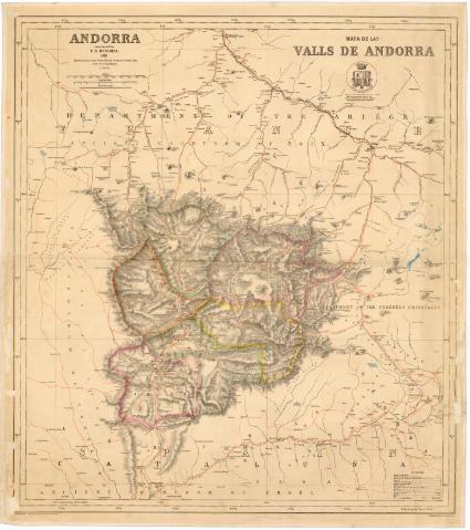
Andorra = Mapa delas Valls de Andorra : Based on the...


 Maps, plans and nautical charts
Andorra = Mapa delas Valls de Andorra : Based on the scale of Fench Ordnance Survey map (Carte de l'Etat Major) (1890)
Maps, plans and nautical charts
Andorra = Mapa delas Valls de Andorra : Based on the scale of Fench Ordnance Survey map (Carte de l'Etat Major) (1890)
 Disponible Holdings
 Section: Maps, plans and nautical charts
Uniform title: ANDORRA. Mapas generales. 1:80000 (1890)
Title: Andorra = Mapa delas Valls de Andorra : Based on the scale of Fench Ordnance Survey map (Carte de l'Etat Major) / Cronstructed by F.H. Deverell ; ... H. Deverell, del
Material or type of resouce Area: Escala 1:80000 (O 1°20'-O 1°35'/N 47°65'-N 47°00')
Publication: London : F.S. Keller, lith Red Liori Squáre, 1890
Physical description: 1 mapa : col., montado sobre tela ; 83,5 x 72 cm, pleg. en 42 x 72 cm
Notes: Escala gráfica de 10000 metros [= 12,5 cm], 5 millas inglesas [= 10 cm]. Proyec. cónica. Red geografica de 10' en 10'
Relieve representado por normales
Tabla de signos convencionales para indicar vías de comunicación, límites de países, puentes, etc
Nota: "Suspice : Sunt Vallis neutrius stremmata, suntque regna quibus gaudeut pobilarz regi. Singula si Popuos alus, Andorra beaurunt Ouidni Juacta feveut eurea scecle tibi?"
En el ángulo superior derecho, escudo de Andorra
FRN
Materia / lugar / evento: Mapas generales
Valles
Fronteras
Divisiones administrativas
1890
Pirineos Orientales
Francia
Other authors: Deverell, F.H
Keller, F. S
UDC: 912:[551.43:341.222](467.2)'1890'
(44-328 Pirineos orientales)
Type of publication:
Maps
Rights:
Préstamo:
Disponible
