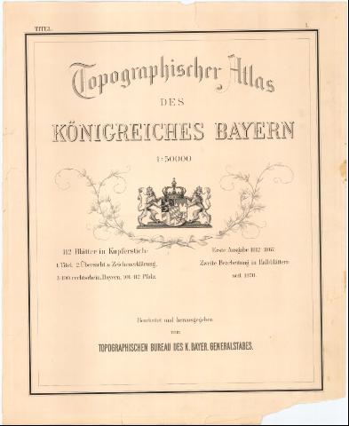
Topographischer Atlas des Konigreiches Bayern


 Disponible Holdings
 Section: Maps, plans and nautical charts
Uniform title: BAVIERA (Alemania). Mapas generales. 1870. 1:50000 (1812-1870)
Title: Topographischer Atlas des Konigreiches Bayern / Berge gestochen John Loehle... [et al.]
Edición: 1. Ausg. 1812-1867, 2. Bearb. in Halbblattern seit 1870
Material or type of resouce Area: Escala 1:50000 ; [proyec. cónica]
Publication: [Munich ?] : Bearbeitet und herausgegeben vom Topographichen Bureau des K. Bayer, Generalstabes, 1870
Physical description: 1 atlas (ca. 150 h.) ; h. de 61x50 cm
Content type: Imagen (cartográfica ; fija ; bidimensional ; visual)
Media type: sin mediación
Notes: Coordenadas referidas, al parecer al meridiano de Hierro (O4#35'-E2#20'/N50#40'-N47#05'). Recuadro geográfico de 1# en 1#
Relieve representado por normales
Tabla de signos convencionales para indicar lineas ferroviarias, caminos y carreteras de diferente categoría, cultivos, ríos, canales, iglesias y tipografia empleada para núcleos de población de distinta categoría
En el margen superior derecho nota sobre las alturas que están indicadas en metros, '(Hohenangaben in Metern, Gegenuber Normal Null durchschn + 1,3 m)'
Incluye mapa índice con tabla de signos empleados
En la hoja n.1 de titulo, mención de responsabilidad y título aparece escudo de Baviera sujetado por dos leones
Acompañado de 7 mapas indices de diferentes fechas (1885-1910) en las que se indican las hojas recibidas, medias hojas y hojas transformadas, además de pequeño folleto explicativo cuyo autor es Oberst Karl von Orff
Las hojas del atlas van numeradas hasta el número 112, pero la mayoría están formadas por dos partes correspondientes al Este y al Oeste por lo que serían 195 hojas en total. Faltan las hojas números 3-4, Oeste : 6, 9, 13, 14, 36, 37, 41, 42, 43, 44, 47, 48, 49, 50, 51, 53, 54, 55, 56, 59, 61, 95, 101, 102, 103, 104, 105, 106, 108, 109 y 110, Este : 64, 65, 66, 69, 74, 75, 76, 79 y 83. Se dispone de algunas hojas repetidas
Other authors: Loehle, John
UDC: 912(430-328 Baviera)'1812/1870'
430-328 Baviera
Type of publication:
 Maps
Maps
Rights:
Préstamo:
Disponible
