Thoogh - Heemraetschap Vande Uytwaterende Sluysen in...


 Maps, plans and nautical charts
Thoogh - Heemraetschap Vande Uytwaterende Sluysen in Kennemerland't ende West - Vrieslandt (17-- ?)
Maps, plans and nautical charts
Thoogh - Heemraetschap Vande Uytwaterende Sluysen in Kennemerland't ende West - Vrieslandt (17-- ?)
 Disponible Holdings
 Section: Maps, plans and nautical charts
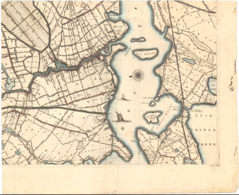
Title: Thoogh - Heemraetschap Vande Uytwaterende Sluysen in Kennemerland't ende West - Vrieslandt / Ionannes Douw ; Koenraet Decker Sculpsit ; Abraham Deur Scripsit
Material or type of resouce Area: Escala [ca. 1:40000], 1500 Sestien hondert Rhynlande roede malekende ontrent een vre gaens [= 18 cm]
Publication: [Amsterdam ? : s.n., 17-- ?]
Physical description: 1 plano en 16 h. : col. ; h. de 56,5x67 cm
Notes: Orientado con lis en rosa de 8 vientos
Relieve de perfil
Indica caminos y cultivos
Representación de figuras humanas bajo el título con sirenas, tritones y escudo real con aguila bicéfala. Coleccion de escudos de armas
Materia / lugar / evento: Mapas generales
Siglo XVIII
Other authors: Douw, Jan Jansz
Deur, Abraham Jansz
Decker, Coenraet
UDC: 912(492-328 Holanda Septentrional)'17'
492-328 Holanda Septentrional
Type of publication:
Maps
Rights:
Préstamo:
Disponible
