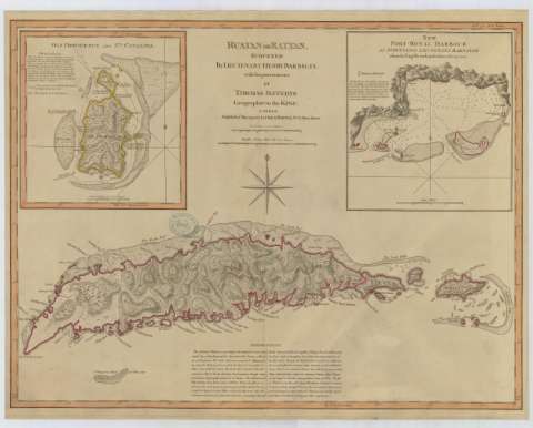
Ruatan or Ratan


Section: Maps, plans and nautical charts
Title: Ruatan or Ratan / surveyed by Lieutenant Henry Barnsley ; with Improvements by Thomas Jefferys, Geographer to the King
Material or type of resouce Area: Escala [ca. 1:137551], 10 statute miles [= 11'7 cm]
Publication: [London] : Laurie & Whittle, 1794
Physical description: 1 mapa : col., papel agarbanzado, montado sobre tela ; 49 x 63 cm
Content type: Imagen cartográfica
Media type: computadora
Carrier type: recurso en línea
Notes: Comprende la isla de Roatán perteneciente al departamento islas de la Bahía en Honduras, además de una descripción de isla Providencia y Santa Catalina pertenecientes al departamento San Andrés en Colombia
Escala gráfica también dada en 2 leguas de 20 al grado [= 8'2 cm]. Coordenadas referidas a los meridianos de Londres (O 87°44'17'' O 86°46'36''/N 16°47'00'' N 16°15'00'') y de Ferro O 70°10'14'' O 69°12'33''). Orientado con lis en rosa de ocho vientos
En nota se explica la importancia estratégica de la isla, su ganada, bosques y clima
Figura el sello del Depósito General Topográfico de Ingenieros
Inserta: "Old Providence and Sta. Catalina". Escala [ca. 1:67750], 1 legua de 20 al grado [= 8'2 cm]. Coordenadas referidas a los meridianos de Ferro (O 63°12'30''--O 63°10'30''/N 13°42'20''--N 13°30'10'') y de Londres (O 70°10'14''--O 69°12'33''). Orientado con lis. En nota se informa sobre las características de las islas ; "New Port-Royal Harbour / as surveyed by Lieutenant Barnsley when the English took posession of it in 1742". Escala [ca. 1:23441], 1 milla [náutica] [= 7'9 cm]. Orientado con lis. En nota se informa sobre las características del puerto. Ambos 21 x 20 cm
Materia / lugar / evento: Mapas generales
Islas
1742
1794
Providencia (Colombia; isla)
Santa Catalina (Isla)
UDC: 728.3-17
861.88
Type of publication:
 Maps
Maps
Rights:
Préstamo:
 Disponible
