Map of the city of Chicago


Section: Maps, plans and nautical charts
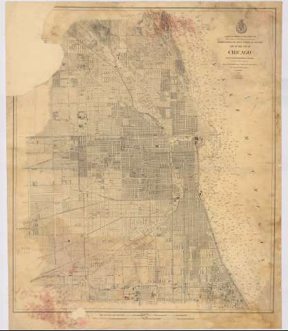
Title: Map of the city of Chicago / Project from a Trigonometrical Survey and executed under the orders of Major C.B. Comstock Corps of Engrs. Brvt. Brig. Genl. U.S.A. ; from local Surveys made by J.R. Mayer ; drawn for engraving by A. de Witzleben
Material or type of resouce Area: Escala [ca. 1:13.467]. 2 miles [= 23,9 cm]
Publication: Estados Unidos : Corps of Engineers, 1872
Physical description: 1 plano : montado sobre tela ; 72 x 62 cm
Content type: Imagen cartográfica
Media type: computadora
Carrier type: recurso en línea
Notes: Escala también expresada en metros
Indica sondas batimétricas
Indica los nombres de las principales calles
Escudo en el ángulo superior derecho
Materia / lugar / evento: Espacios urbanos
Lagos
Batimetría
Planos de población
Calles
1872
Illinois
Estados Unidos
Other authors: Comstock, Cyrus Ballou
Witzleben, A. von
Estados Unidos. Army. Corps of Engineers
UDC: 773Chicago
Type of publication:
 Maps
Maps
Rights:
Préstamo:
 Disponible
