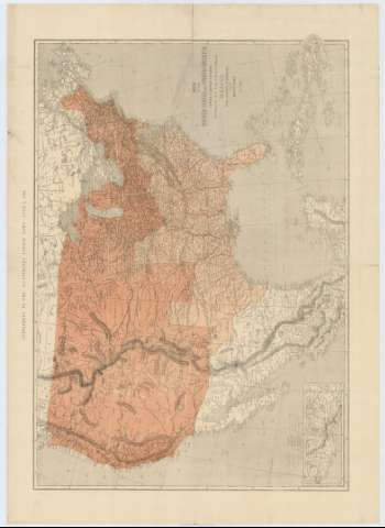
Map of the United States of North America Upper & Lower...


 Maps, plans and nautical charts
Map of the United States of North America Upper & Lower Canadá, New Brunswick, Nova Scotia & British Columbia,...
Maps, plans and nautical charts
Map of the United States of North America Upper & Lower Canadá, New Brunswick, Nova Scotia & British Columbia,...
 Disponible Holdings
 Section: Maps, plans and nautical charts
Uniform title: Estados Unidos. Mapas generales. 1861. 1:5905871 (1861?)
Title: Map of the United States of North America Upper & Lower Canadá, New Brunswick, Nova Scotia & British Columbia, Mexico, Cuba, Jamaica, St. Domingo and the Bahama Islands / By T. Euling
Material or type of resouce Area: Escala [ca. 1:5905871], 400 statute miles [= 10'9 cm] (O 120°--O 70°/N 49°--N 15°)
Publication: Londres : London News : 1861
Physical description: 1 mapa : col., montado sobre tela ; 65 x 93 cm
Content type: Imagen cartográfica
Media type: computadora
Carrier type: recurso en línea
Notes: Comprende Estados Unidos, México, Cuba, Jamaica, Puerto Rico, la isla de La Española y la parte meridional de Canadá
Escala gráfica también expresada en 400 millas geográficas, 150 leguas mexicanas, 60 miriámetros franceses y 60 millas germánicas
Relieve por normales
Lavado en siena la parte correspondiente a los Estados Unidos
En el margen superior: "Supplement to the illustrated London News, June 1, 1861"
Other authors: Euling, T
London News
UDC: 73
72
729
71-13
Type of publication:
Maps
Rights:
Préstamo:
Disponible
