Campaing of the Army of West Mississippi : Maj. Gen. E.R...


 Maps, plans and nautical charts
Campaing of the Army of West Mississippi : Maj. Gen. E.R.S. Canby, com'dg., in southern Alabama, March and April, 1865 (189-?)
Maps, plans and nautical charts
Campaing of the Army of West Mississippi : Maj. Gen. E.R.S. Canby, com'dg., in southern Alabama, March and April, 1865 (189-?)
 Disponible Holdings
 Section: Maps, plans and nautical charts
Uniform title: ESTADOS UNIDOS. SE. Maniobras de campaña. 189. 1:315500 (1865)
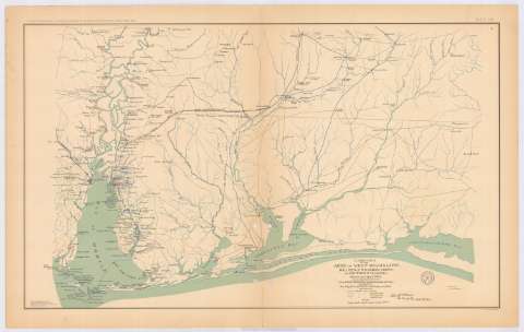
Title: Campaing of the Army of West Mississippi : Maj. Gen. E.R.S. Canby, com'dg., in southern Alabama, March and April, 1865 / drawn under direction of Lieut. S.E. Mc. Gregory, Comdy. Topographical Party ; by order of But. Maj. Mc. Alester, Chief Engineer A.D.W.M.
Material or type of resouce Area: Escala [ca. 1:315500], 10 miles [= 5,1 cm]
Publication: Washington : Government Printing Office, [189-?] (N.Y. [Nueva York] : Julius Bien & co.)
Physical description: 1 mapa : col. ; 41x69 cm, en h. de 47x75 cm
Content type: Imagen cartográfica
Media type: computadora
Carrier type: recurso en línea
Notes: En : Atlas to accompany the Official Records of the Union and Confederate Armies 1861-1865. - Plate CX, n 1
Relieve : lineas perpendiculares normales
Mapa que acompaña al informe del 'Maj. Gen. E.R.S. Canby, U.S. Army, dated New Orleans, La., June 1, 1865
Figura en margen inferior : Series I, vol. XLIX
Representadas mediante diferente color las posiciones de cada ejército
Leyenda de signos utilizados
Figura, impresa, firma del But. Maj. Mc. Alester
En : Atlas to accompany the Official Records of the Union and Confederate Armies 1861-1865
Materia / lugar / evento: Guerra civil
Maniobras de campaña
Itinerarios
Arma de Caballería
Carreteras
Líneas ferroviarias
Ríos
1865
Alabama
Florida
Mississippi
Estados Unidos
Other authors: Canby, E.R.S Major General
McAlester
McGregory, S. E
UDC: 912:355.4]:[355.52:656.02:357.1+625.7:625.1](761+759)'1865'
761
(759)
Type of publication:
Maps
Rights:
Préstamo:
Disponible
