Central Virginia : [map] : showing Lieut. Gen. V.J....


 Maps, plans and nautical charts
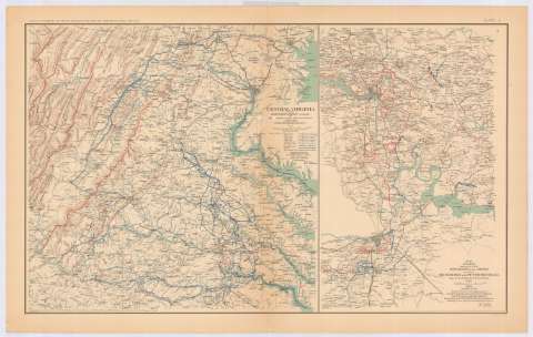
Central Virginia : [map] : showing Lieut. Gen. V.J. Grant's Campaign and ma [...] es of the Armies under his... (189-?)
Maps, plans and nautical charts
Central Virginia : [map] : showing Lieut. Gen. V.J. Grant's Campaign and ma [...] es of the Armies under his... (189-?)
 Disponible Holdings
 Section: Maps, plans and nautical charts
Uniform title: VIRGINIA (Estados Unidos) (Estado). Central. Operaciones bélicas. 189 (1864-1865). 1:670554
Title: Central Virginia : [map] : showing Lieut. Gen. V.J. Grant's Campaign and ma [...] es of the Armies under his command in 1864-1865 / Engineer Bureau, War Dept. ; prepared by order of the Secretary of war for the officers of the U.S. Army under the Command of Lieut. Gen. U.S. Grant
Material or type of resouce Area: Escala [ca. 1:670554], 20 miles [= 4'8 cm]
Publication: Washington : Government Printing Office, [189-?] (N.Y. [Nueva York] : Julius Bien & co.)
Physical description: 1 mapa : col. ; 42x43 cm, en h. de 47x75 cm
Content type: Imagen cartográfica
Media type: computadora
Carrier type: recurso en línea
Notes: En : Atlas to accompany the Official Records of the Union and Confederate Armies 1861-1865. - Plate C, n 1
Relieve : lineas perpendiculares normales
Mapa que acompaña al informe del 'Chief of Engineers, U.S. Army'
Leyenda de símbolos
Figura en margen inferior : Series III
Representadas mediante distintos colores las posiciones de ambos ejércitos
En : Atlas to accompany the Official Records of the Union and Confederate Armies 1861-1865
Materia / lugar / evento: Guerra civil
Itinerarios
Operaciones bélicas
Redes de transporte
1865
Estados Unidos
Other authors: Grant Lieutenant General
Estados Unidos. War Department. Engineer Bureau
Government Printing Office (Estados Unidos)
UDC: 912:355.4]:656.02(755-191.2)'1864/1865'
755-191.2
Type of publication:
Maps
Rights:
Préstamo:
Disponible
