Map of a line of defenses in the Alleghanies A : general...


 Maps, plans and nautical charts
Map of a line of defenses in the Alleghanies A : general map (189-?)
Maps, plans and nautical charts
Map of a line of defenses in the Alleghanies A : general map (189-?)
 Disponible Holdings
 Section: Maps, plans and nautical charts
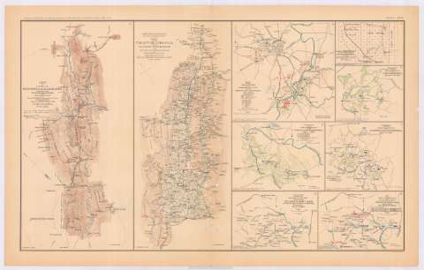
Title: Map of a line of defenses in the Alleghanies A : general map / compiled from Whitcomb's railroad map and original surveys by Lieut. Koerner's Topographical Party ; under direction of Capt. C.R. Howard, C.S.E., H.J. Miller, Asst. and Drftsm
Material or type of resouce Area: 1:320000
Publication: Washington : Government Printing Office, [189-?] (N.Y. [Nueva York] : Julius Bien & co.)
Physical description: 1 mapa : col. ; 21 x 41 cm en h. de 47 x 75 cm
Content type: Imagen cartográfica
Media type: computadora
Carrier type: recurso en línea
Notes: Relieve por líneas perpendiculares normales
Orientado con flecha
Representadas en color rojo las posiciones del Ejército Confederado
Nota impresa reproduciendo la manuscrita original: "... from M. Koerner Abr. 25th. 1864... AH. Campbel..."
En: Atlas to accompany the Official Records of the Union and Confederate Armies 1861-1865. Pl. XCIV, n. 1
Materia / lugar / evento: Fortificaciones
Guerra civil
Montañas
1864
New Castle
Staunton
Virginia
Estados Unidos
Other authors: Koerber, V. E. van
Howard, C. R
Miller, H. J
UDC: 912:355.4]:623.2(755 Allegheny Mountains)'1864'
237 Allegheny)
755 Allegheny Mountains
Type of publication:
Maps
Rights:
Préstamo:
Disponible
