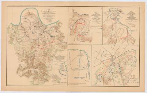
Topographical map of the battle - field of Nashville,...


 Maps, plans and nautical charts
Topographical map of the battle - field of Nashville, TENN. 15th and 16th dec, 1864 (189-?)
Maps, plans and nautical charts
Topographical map of the battle - field of Nashville, TENN. 15th and 16th dec, 1864 (189-?)
 Disponible Holdings
 Section: Maps, plans and nautical charts
Title: Topographical map of the battle - field of Nashville, TENN. 15th and 16th dec, 1864 / prepared under the direction of Col. Wm. Merrill, 1st US VV Engineers, Chief Engineer Dept. of the Cumberland ; by Major James R. Willett, 1st USVV Engineers, Chief Inspector RR Defenses Dept. of the Cumberland ; surveyed by Chs. Peseux and John H. Willett, 1864-1865 ; drawn by Charles Peseux
Material or type of resouce Area: Escala [ca. 1:46038], 8000 feet
Publication: Washington : Government Printing Office, [189-?] (N.Y. [Nueva York] : Julius Bien & co.)
Physical description: 1 mapa : col. ; 42x32 cm, en h. de 47x75 cm
Content type: Imagen cartográfica
Media type: computadora
Carrier type: recurso en línea
Notes: En : Atlas to accompany the Official Records of the Union and Confederate Armies 1861-1865. - Plate LXXIII, n 1
Relieve : curvas de nivel
Orientado con flecha
Leyenda de signos utilizados
Figura un margen inferior izquierdo : Series 1. Vol XLV
En : Atlas to accompany the Official Records of the Union and Confederate Armies 1861-1865
Materia / lugar / evento: Guerra civil
Batallas
Estrategia militar
Baterías
Fortificaciones
Líneas ferroviarias
Planos de población
Mapas topográficos
S.XIX
Estados Unidos
Other authors: Willett, James R
Willett, John H
Merrill, W. E
Peseux, Charles
UDC: 912:355.4]:[355.422+355.43+623.1+623.2+625.1](768 Nashville)'1864/1865'
912:314(768 Nashville)(084.3)
912:528.4(768 Nashville)'1864/1865'
768 Nashville
Type of publication:
Maps
Rights:
Préstamo:
Disponible
