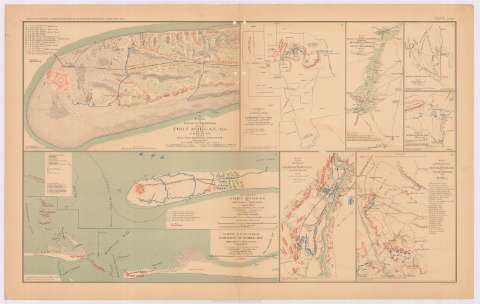
A plan of siege operations against Fort Morgan, ALA., by...


 Maps, plans and nautical charts
A plan of siege operations against Fort Morgan, ALA., by the U.S. Forces under Maj. Gen. Gordon Granger, Auggust, 1864 (189-?)
Maps, plans and nautical charts
A plan of siege operations against Fort Morgan, ALA., by the U.S. Forces under Maj. Gen. Gordon Granger, Auggust, 1864 (189-?)
 Disponible Holdings
 Section: Maps, plans and nautical charts
Title: A plan of siege operations against Fort Morgan, ALA., by the U.S. Forces under Maj. Gen. Gordon Granger, Auggust, 1864 / capt. John C. Palfrey, Corps of engr's ; lient. A.H. Burnham, Lieut. Chas. J. Allen, corps of eng'rs in charge of works ; surveyed and chawn by Capt. W.H. Wheeler, Lt. S.E. Mc. Gregory
Material or type of resouce Area: Escala [ca. 1:6224], 1000 feet [= 4,9 cm]
Publication: Washington : Government Printing Office, [189-?] (N.Y. [Nueva York] : Julius Bien & co.)
Physical description: 1 plano : col. ; 21x35 cm, en h. de 47x75 cm
Content type: Imagen cartográfica
Media type: computadora
Carrier type: recurso en línea
Notes: En : Atlas to accompany the Official Records of the Union and Confederate Armies 1861-1865. - Plate LXIII, n 1
Relieve : líneas perpendiculares normales
Orientado con flecha
Mapa que acompaña el informe del : Capt. M.D. Mc. Alester
Figura en el margen inferior izquierdo : Series I. Vol. XXXIX. Part 1. Page 412
Figura fortaleza representada mediante poligón pentagonal
Figura leyenda alfanumérica señalando puntos destacados del mapa
En : Atlas to accompany the Official Records of the Union and Confederate Armies 1861-1865
Materia / lugar / evento: Guerra civil
Asedios
Operaciones bélicas
Baterías
Fortificaciones
Arma de Artillería
Líneas ferroviarias
1864
Estados Unidos
Other authors: Palfrey, John C
Burnham, A.H
Allen, Chas. J
Wheeles. W.H
McGregory, S. E
UDC: 912:355.4]:[355.44+623.2+625.1+358.1+623.1](761 Fort Morgan)'1864'
(761 Fort Morgan)
Type of publication:
Maps
Rights:
Préstamo:
Disponible
