Map of Orange County and c., VA embracing the details and...


 Maps, plans and nautical charts
Map of Orange County and c., VA embracing the details and plan of operations of Confederate and Federal forces at... (189-?)
Maps, plans and nautical charts
Map of Orange County and c., VA embracing the details and plan of operations of Confederate and Federal forces at... (189-?)
 Disponible Holdings
 Section: Maps, plans and nautical charts
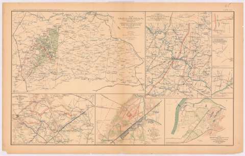
Title: Map of Orange County and c., VA embracing the details and plan of operations of Confederate and Federal forces at Mine run and Rapidan river : by order of Lt. Col. W.P. Smith, Lt. Col. of Engrs. Topl. Office ANV / prepared by J. Paul Hoffman
Material or type of resouce Area: Escala [ca. 1:191587], 5 miles [= 4,2 cm]
Publication: Washington : Government Printing Office, [189-?] (N.Y. [Nueva York] : Julius Bien & co.)
Physical description: 1 mapa : col. ; 26x42 cm, en h. de 47x75 cm
Content type: Imagen cartográfica
Media type: computadora
Carrier type: recurso en línea
Notes: En : Atlas to accompany the Official Records of the Union and Confederate Armies 1861 - 1865. - Plate XLV, n 1
Leyenda de signos utilizados
Orientado con flecha
Mapa que acompaña al informe de : General R.E. Lee
Figura en el margen inferior izquierdo : Series I. Vol XXIX. Part 1. Page 830
Representadas mediante distintos colores las fuerzas de los dos ejércitos
En : Atlas to accompany the Official Records of the Union and Confederate Armies 1861 - 1865
Materia / lugar / evento: Guerra civil
Operaciones bélicas
Estrategia
Fortalezas militares
Líneas ferroviarias
Carreteras
Itinerarios
S.XIX
Estados Unidos
Other authors: Hoffman, J. Paul
UDC: 912:355.4]:[355.43+623.1+625.1+625.7+656.02](755)'1861/1865'
755
Type of publication:
Maps
Rights:
Préstamo:
Disponible
