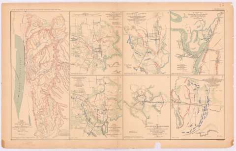
Map of the defenses of Vicksburg, Miss.


 Disponible Holdings
 Section: Maps, plans and nautical charts
Title: Map of the defenses of Vicksburg, Miss. / surveyed and drown by H.A. Pattison, C.E.
Material or type of resouce Area: Escala [ca. 1:26822], 1 mille [= 6,1 cm]
Publication: Washington : Government Printing Office, [189-?] (N.Y. [Nueva York] : Julius Bien & co.)
Physical description: 1 mapa : col. ; 42x19 cm, en h. de 47x75 cm
Content type: Imagen cartográfica
Media type: computadora
Carrier type: recurso en línea
Notes: En : Atlas to accompany the Official Records of the Union and Confederate Armies 1861 - 1865. - Plate XXXVII, n 1
Escala gráfica además en : feet
Relieve : líneas perpendiculares normales
Orientado con flecha
Figura en el margen inferior izquierdo : 'Series 1. Vd. XXIV part 1 page 2 page 330'
Leyenda de signos convencionales
Figura texto impreso con los autores
Mapa que acompaña al informe del : Lient Gen. John C. Pemberton and Maj. S.M. Kockett
En : Atlas to accompany the Official Records of the Union and Confederate Armies 1861 - 1865
Materia / lugar / evento: Guerra civil
Asedios
Estrategia militar
Operaciones bélicas
Baterías
Planos de población
1863
Vicksburg
Estados Unidos
Other authors: Pattison, m.A C.E
UDC: 912:355.4]:[355.44+355.43+623.1](762)'1863'
912:314(762 Vicksburg) (084.3)
762
Type of publication:
 Maps
Maps
Rights:
Préstamo:
Disponible
