Map of the country between Milliken's Bend, L A and...


 Maps, plans and nautical charts
Map of the country between Milliken's Bend, L A and Jackson, Miss showing the recites followed by the Army of the... (189-?)
Maps, plans and nautical charts
Map of the country between Milliken's Bend, L A and Jackson, Miss showing the recites followed by the Army of the... (189-?)
 Disponible Holdings
 Section: Maps, plans and nautical charts
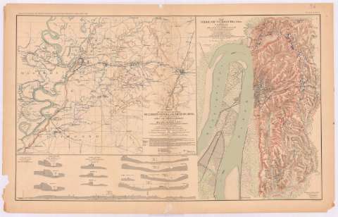
Title: Map of the country between Milliken's Bend, L A and Jackson, Miss showing the recites followed by the Army of the Tennessee under the command Maj. Gen. US Grant, US Vls. in its march from Milliken's Bend to near of Vicksburg in april and may 1863 / compiled, surveyed and drawn under the direction of Lt. Co. J.H. Wilson AIG and 1st Lient. Engrs. ; drawn by Maj. Otto H. Matz, Asst. Engr. and 1st Lient L. Helmle 3d Mo. Vol. Inft ... [et al.]
Material or type of resouce Area: Escala [ca. 1:306539], 1 [= 4'2 cm]
Publication: Washington : Government Printing Office, [189-?] (N.Y. [Nueva York] : Julius Bien & co.)
Physical description: 1 mapa : col. ; 32x41 cm, en h. de 47x75 cm
Content type: Imagen cartográfica
Media type: computadora
Carrier type: recurso en línea
Notes: En : Atlas to accompany the Official Records of the Union and Confederate Armies 1861 - 1865. - Plate XXXVI, n 1
Relieve : sombreado
Orientado con flecha
Figura nota explicativa del mapa
Leyenda de signos utilizados
Figura en el margen inferior izquierdo : 'Serie 1 Vol XXIV part 1 page 130'
En : Atlas to accompany the Official Records of the Union and Confederate Armies 1861 - 1865
Materia / lugar / evento: Guerra civil
Operaciones bélicas
Estrategia militar
Asedios
1863
Estados Unidos
Other authors: Wilson, James Harrison
Matz, Otto H
UDC: 912:355.4]:[355.43+355.44](775)'1863'
762
Type of publication:
Maps
Rights:
Préstamo:
Disponible
