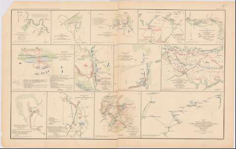
Rough sketch of reconnaisance : May 24th 1862


 Disponible Holdings
 Section: Maps, plans and nautical charts
Uniform title: HANOVER (Estados Unidos) (Virginia). Operaciones bélicas. 1892 (1862). Escala indeterminada
Title: Rough sketch of reconnaisance : May 24th 1862 / R.H. Rush Col. Lancers
Material or type of resouce Area: Escala indeterminada
Publication: Washington : Government Printing Office, [189-?] (N.Y. [Nueva York] : Julius Bien & co.)
Physical description: 1 mapa : col. ; 11x13 cm, en h. de 47x75 cm
Content type: Imagen cartográfica
Media type: computadora
Carrier type: recurso en línea
Notes: En : Atlas to accompany the Official Records of the union and Confederate Armies 1861 - 1865. - Plate XXI, n 1
Figura leyenda alfabética de posiciones tropas
Mapa que acompaña al informe del Col. R.H. Rush
Figura en margen inferior : Series 1. Vol. XI. Part 1. Page 667
En : Atlas to accompany the Official Records of the Union and Confederate ARmies 1861 - 1865
Materia / lugar / evento: Guerra civil
Operaciones bélicas
Estrategia militar
1862
Estados Unidos
Other authors: Rush, R.H Colonel
UDC: 912:355.4]:355.43(755 Hanover)'1862'
755 Hanover
Type of publication:
 Maps
Maps
Rights:
Préstamo:
Disponible
