Military reconnaissance : [map] : vianity of Gauley...


 Maps, plans and nautical charts
Military reconnaissance : [map] : vianity of Gauley Bridge, Department of Western Virginia, Brig. Gen. W.S.... (189-?)
Maps, plans and nautical charts
Military reconnaissance : [map] : vianity of Gauley Bridge, Department of Western Virginia, Brig. Gen. W.S.... (189-?)
 Disponible Holdings
 Section: Maps, plans and nautical charts
Uniform title: VIRGINIA OCCIDENTAL (Estados Unidos). E. Maniobras militares. 1890 (1861-1865). 1:115779
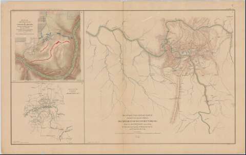
Title: Military reconnaissance : [map] : vianity of Gauley Bridge, Department of Western Virginia, Brig. Gen. W.S. Rosecrans, Commanding / by W.E. Raynolds, Capt. Top. engrs. ; W. Margedant, Capt. O.V. ; W. Angelo Powell, C. engr.
Material or type of resouce Area: Escala [ca. 1:115779], 10 miles [= 13'9 cm]
Publication: Washington : Government Printing Office, [189-?] (N.Y. [Nueva York] : Julius Bien & co.)
Physical description: 1 mapa : col. ; 42x47 cm, en h. de 47x75 cm
Content type: Imagen cartográfica
Media type: computadora
Carrier type: recurso en línea
Notes: En : Atlas to accompany the Official Records of the Union and Confederate Armies 1861 - 1865. - Plate IX, n 3
Relieve : líneas perpendiculares normales
Orientado con flecha
Representadas en distintos colores las fuerzas de los dos ejércitos
En el margen inferior, figura : 'Serie 1. Vol. 5. Page 253
En : Atlas to accompany the Official Records of the Union and Confederate Armies 1861 - 1865
Materia / lugar / evento: Guerra civil
Operaciones bélicas
Estrategia militar
Campamentos militares
S.XIX
Estados Unidos
Other authors: Raynolds, W. F
Margedant, W Capt. O.V
Powell, W. Angelo
UDC: 912:355.4]:[355.4+355.43+355.67](754)'1861/1865'
754
Type of publication:
Maps
Rights:
Préstamo:
Disponible
