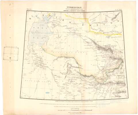
Turkestan With the adjoining portions of the British and...


 Maps, plans and nautical charts
Turkestan With the adjoining portions of the British and Russian territories (1867-1868)
Maps, plans and nautical charts
Turkestan With the adjoining portions of the British and Russian territories (1867-1868)
 Disponible Holdings
 Section: Maps, plans and nautical charts
Uniform title: TURKESTAN. Mapas generales. 1867-1868 (1867). 1:2000000
Title: Turkestan With the adjoining portions of the British and Russian territories / Mapped on the basis of the surveys made by Brithish and Russian Officers up to 1867 ; Compilation by W. H. Scott, Hiel Shading by J. Peyton
Material or type of resouce Area: Escala [ca. 1:2000000], 250 English Miles [= 19'4 cm] ; [proyec. cónica] (E58°-E86°/N47°-N29°)
Publication: [London] : Compiled and Photozincographed under the orders of Lieutt. Colonel J.T. Walker..., 1867-1868 ([London] : Zincographed by C.G. Ollenhach)
Physical description: 1 mapa en 4 h. : col. ; h. de 64'5x86'1 cm
Content type: Imagen cartográfica
Media type: computadora
Carrier type: recurso en línea
Notes: Comprende la región de Turquestán, el noroeste de la India y el norte de Afganistán y Nepal
Relieve representado por normales
Nota relativa a que las alturas están expresadas en pies y a la realización de las triangulaciones
En el margen izquierdo figura un gráfico de distribución de las hojas y en el márgen inferior 'The Russian boundary and Military Distriets are taken from a Map by A. Il y in, St. Petersburgh, receiced in August 1868'
Anotaciones manuscritas, al parecer, por Francisco Coello
Materia / lugar / evento: Mapas generales
1868
Afganistán
Nepal
India
Other authors: Scott W.H
Peyton, J
Walker, James Thomas
Ollenbach, C.G
UDC: 912(47-328 Turquestán)'1867/1868'
(541.35-17)
(540-16)
Type of publication:
Maps
Rights:
Préstamo:
Disponible
