The Empire of China with its principal divisions : drawn...


 Maps, plans and nautical charts
The Empire of China with its principal divisions : drawn from the surveys made by the jefuits with improvements and... (May 12th 1794)
Maps, plans and nautical charts
The Empire of China with its principal divisions : drawn from the surveys made by the jefuits with improvements and... (May 12th 1794)
 Disponible Holdings
 Section: Maps, plans and nautical charts
Uniform title: China. Mapas generales (1794). 1:9000000
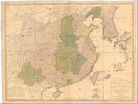
Title: The Empire of China with its principal divisions : drawn from the surveys made by the jefuits with improvements and additions from the Maps of Monsr. D'Anville / M. Borven sculpt.
Material or type of resouce Area: Escala [ca. 1:9000000], 300 british statute miles 69 1/2 to a degree [= 5,3 cm] ; [proyec. cónica]
Publication: London : Laurie and Whittle 53 Fleet Street as the Act directs, May 12th 1794
Physical description: 1 mapa : col., montado sobre tela ; 50,5x66,5 cm
Content type: Imagen cartográfica
Media type: computadora
Carrier type: recurso en línea
Notes: Escalas gráficas de 800 'great Li or Chinese Furlongs 200 to a degree' [= 7,1 cm], 800 'small Li 250 to a degree' [= 5,7 cm] y 80 'sea leagues 20 to a degree' [= 7,1 cm]. Coordenadas referidas al meridiano de Hierro (E108°-E154°/N43°-N18°) Red geográfica de 5° en 5°
Relieve de perfil
Entelado en 8 cuarterones
Materia / lugar / evento: Mapas generales
Divisiones administrativas
Imperios
Topónimos antiguos
1794
China
Other authors: Borven, M
Robert Laurie and James Whittle
UDC: 912(510-328)'1794'
510-328
Type of publication:
Maps
Rights:
Préstamo:
Disponible
