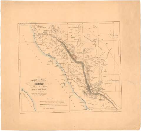
Skizze einer Karte von Asyr und einem Theile von Hedias...


 Maps, plans and nautical charts
Skizze einer Karte von Asyr und einem Theile von Hedias und Nedid nach Chedufeaus Materialien (18--)
Maps, plans and nautical charts
Skizze einer Karte von Asyr und einem Theile von Hedias und Nedid nach Chedufeaus Materialien (18--)
 Disponible Holdings
 Section: Maps, plans and nautical charts
Uniform title: ARABIA SAUDI. O. Mapas físicos. 3:4000000 (18)
Title: Skizze einer Karte von Asyr und einem Theile von Hedias und Nedid nach Chedufeaus Materialien / entroorfen von den Capt. Ing. Galinier und Ferret..
Material or type of resouce Area: 1:4000000
Publication: [Deutschland] : Umdruck - zeichning b. H. Delius, [18--]
Physical description: 1 mapa : col. ; 43,2 x 48,6 cm en h. de 63,2 x 68,1 cm
Content type: Imagen cartográfica
Media type: computadora
Carrier type: recurso en línea
Notes: En: Zum Atlas von Varder Asien gehórig Helt V Arabien
Escalas gráficas de 12 miriametros, 25 leguas de 25 al grado, 60 millas árabes de 56 1/3 al grado y 25 "Stundennach Kararoanenschritt". Proyec. Mercator. Coordenadas referidas al meridiano de París (E 36°-E 42°15'/N 22°-N 17°). Red geográfica de 1 en 1 grado
Relieve representado por normales
Materia / lugar / evento: Mapas generales
S.XIX
Arabia Saudí
Asia
Other authors: Galinier, Joseph Germain
Delius, Hermann
Ferret, Pierre Victor Adolphe
UDC: 912(532-15)'18'
532-15
Type of publication:
Maps
Rights:
Préstamo:
Disponible
