Reduzirte Karte vom Sunda oder Borneo - Meere... Karte...


 Maps, plans and nautical charts
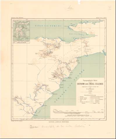
Reduzirte Karte vom Sunda oder Borneo - Meere... Karte von Djava den Kleinen Sunda Inseln, Celebes... (1835)
Maps, plans and nautical charts
Reduzirte Karte vom Sunda oder Borneo - Meere... Karte von Djava den Kleinen Sunda Inseln, Celebes... (1835)
 Disponible Holdings
 Section: Maps, plans and nautical charts
Uniform title: INSULINDIA. Cartas náuticas (1835). 1:2000000
Title: Reduzirte Karte vom Sunda oder Borneo - Meere... Karte von Djava den Kleinen Sunda Inseln, Celebes... / gest. v. W. Jattnig in Berlin von F. Berghaus
Material or type of resouce Area: Escala [ca. 1:2000000] ; [proyec. Mercator] (E102°00'-E120°00'/N1°20'-S10°45')
Publication: Gotha : bei J. Perthes, 1835
Physical description: 1 carta náutica ; 61x94 cm en h. de 67,8x101,2 cm
Content type: Imagen cartográfica
Media type: computadora
Carrier type: recurso en línea
Notes: Presenta además 6 cartas náuticas de Batavia, estrecho de Gaspar, estrecho de Sunday estrecho de Lambock y 9 perfiles
Pertenece al 'Berhaus atlas von Asia. - N. 17'
Escala hallada a partir de un grado de la latitud [= 5,9 cm]. Red geográfica de 1° en 1°. Orientado con lis en nudo de rumbos
Relieve representado por normales y sondas batimétricas
Indica veriles y bajos
Tabla de signos convencionales para indicar las divisiones administrativas
Procede de la 'Colección Coello'
Materia / lugar / evento: Cartas náuticas
Islas
1835
Java (Isla)
Célebes (Isla)
Indonesia
Other authors: Berhaus
Jaettnig, Wilhelm
Perthes, Justus, 1749-1816
UDC: 912:[551.46:551.42](91-11)'1835'
(91 Java, isla)
(91 célebes,islas)
Type of publication:
Maps
Rights:
Préstamo:
Disponible
