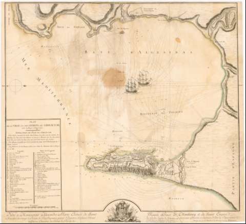
Plan de la ville et des Fort de Gibraltar, avec la Baye...


 Maps, plans and nautical charts
Plan de la ville et des Fort de Gibraltar, avec la Baye d'Algeciras (1781)
Maps, plans and nautical charts
Plan de la ville et des Fort de Gibraltar, avec la Baye d'Algeciras (1781)
 Disponible Holdings
 Section: Maps, plans and nautical charts
Uniform title: ALGECIRAS (Cádiz) (Bahía). Defensa de costas (1781). 1:21.000
Title: Plan de la ville et des Fort de Gibraltar, avec la Baye d'Algeciras / Ch. Mangein del. et Sculp. ; Presenté par son trés Humble et trés obeissant serviteur Mangein
Material or type of resouce Area: Escala [ca. 1:21.000], 1200 toises [= 11,3 cm]
Publication: Se Vend A Paris : chez l'Auteur, rue des Francs - bourgeois, Parte St. Michel Morison de l'Arquebusier, [1781]
Physical description: 1 mapa : col., montado sobre tela ; 63,3 x 69,7 cm
Notes: Dedicatoria: "... á Monseigneur Alexandre Marie Eleónor de Saint Mauris, Prince de Montbarey et du Saint Empire..."
Orientado con lis en cuadrante
Relieve representado por normales
Relación de las principales baterías, muralla, bastiones, edificios civiles, caminos, almacenes y jardines de la plaza de Gibraltar indicados por clave alfabética y numérica
Indica fondeaderos, bajos y sondas batimétricas de 6 pies
Señala torres de defensa costera y líneas de ángulo de tiro de las baterías
Nota sobre el plan de fuegos para atacar la plaza y los navíos que tratan de defenderla
Representación de dos galeras en el mar
En el margen inferior escudo nobiliario con atributos militares
Materia / lugar / evento: Defensa de costas
Fortificaciones
Baterías
Fondeaderos
Bahías
Batimetría
1781
Gibraltar
Cádiz (Provincia)
Andalucía
Other authors: Mangein, Charles
UDC: (460.355 Algeciras)
Type of publication:
Maps
Préstamo:
Disponible
