Part of Marocco between Ceuta, Tetuan & Tanger : from...


 Maps, plans and nautical charts
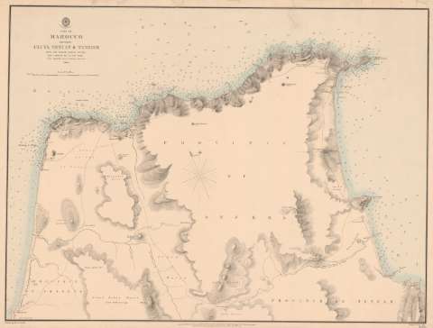
Part of Marocco between Ceuta, Tetuan & Tanger : from the french survey of 1855 (26 Jany. 1860)
Maps, plans and nautical charts
Part of Marocco between Ceuta, Tetuan & Tanger : from the french survey of 1855 (26 Jany. 1860)
 Disponible Holdings
 Section: Maps, plans and nautical charts
Uniform title: Marruecos. Cartas náuticas (1860). 1:100000
Title: Part of Marocco between Ceuta, Tetuan & Tanger : from the french survey of 1855 / ... a sketch by J.D. Hay Esqre. ; Drawn by E.J. Powell
Material or type of resouce Area: Escala [ca. 1:100000 sea miles [= 9'2 cm] ; [proyec. cónica]
Publication: London : Published at the Almiralty..., 26 Jany. 1860 (Malby & Sons Lith)
Physical description: 1 mapa : montado sobre tela ; 59'5x78'2 cm
Content type: Imagen cartográfica
Media type: computadora
Carrier type: recurso en línea
Notes: Escala gráfica de 3000 yardas [= 2'7 cm]. Orientado con lis indica ángulo de declinación magnética
Relieve representado por normales, curvas de configuración y puntos acotados. Sondas batimétricas
En el ángulo inferior : Sold by J.D. Potter Agent for the Admiralty Charts 31 Poultry & Il King Street Tower Hill
Other authors: Hay, John Drummond
Powell, E.J
Gran Bretaña. Admiralty
UDC: 912:[551.46:551.468](64-17)'1860'
(647.1)
(64.32 8 Tetuan)
(64-328 Tánger)
Type of publication:
Maps
Rights:
Préstamo:
Disponible
