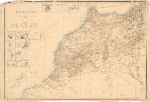
Marocco


Section: Maps, plans and nautical charts
Uniform title: Marruecos. Mapas generales (1889). 1:1584000
Title: Marocco / compiled in the intelligence Division, War Office ; E. Marning compr. and Lit.
Material or type of resouce Area: Escala 1:1584000 ; [proyec. cónica] (O16°-O0°/N36°-N27°)
Publication: [London] : Lithod. at the Intelligence [Division], 1889
Physical description: 1 mapa : col., montado sobre tela ; 67,3x100,5 cm
Content type: Imagen cartográfica
Media type: computadora
Carrier type: recurso en línea
Notes: Red geográfica de 2° en 2°
Relieve representado por normales
Relación de terminos árabes y su traducción en inglés
En el ángulo inferior izquierdo, 'Int. Div. N 746'
Inserta : Tangier. - Escala 1:20000. Ceuta. - Escala 1:100800. Larash. - Escala [ca. 1:38000]. Rabat - Sali. - Escala [ca. 1:60000]. Mazagan. - Escala 1:48500. Mogador or Suiza. - Escala 1:31760. Safi. - Escala 1:48500. Dar el Baida or Casa Blanca. - Escala 1:72900. Agadir. - Escala 1:50000
Al verso manuscrito en rojo, '20'
Materia / lugar / evento: Mapas generales
Costas
Cables submarinos
1889
Other authors: Marning, E
Gran Bretaña. War Office. Intelligence Division
UDC: 912:[551.468:621.315.2](64)'1889'
64
Type of publication:
 Maps
Maps
Rights:
Préstamo:
 Disponible
