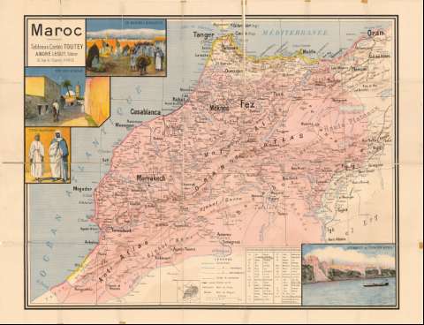
Maroc


Section: Maps, plans and nautical charts
Uniform title: Marruecos. Mapas generales. 1:1000000 (190)
Title: Maroc / Toutey
Material or type of resouce Area: Escala [1:1000000] ; [proyec. cónica]
Publication: Paris : André Lesot, 10 rue de l'Eperon, [190- ?]
Physical description: 1 mapa : col. ; 100,5x129,8 cm, pleg. en 73,3x51,9 cm
Content type: Imagen cartográfica
Media type: computadora
Carrier type: recurso en línea
Notes: Coordenadas referidas al parecer al meridiano de Paris (O14°-O2°/N36°-N29°). Red geográfica de 2° en 2°
Relieve representado por sombreado
Tabla de signos convencionales para indicar distintos tipos de cursos de agua, pistas de caravanas, ferrocarriles, nombres de tribus y regiones
Relación de las abreviaturas de los términos en árabe y su traducción en francés
Representación de cuatro escenas cotidianas del pueblo árabe
Encuadernado en papel naranja
Materia / lugar / evento: Mapas generales
S.XX
Other authors: Toutey, E
Lesot, André
UDC: 912(64)'1900/1909'
64
Type of publication:
 Maps
Maps
Rights:
Préstamo:
 Disponible
