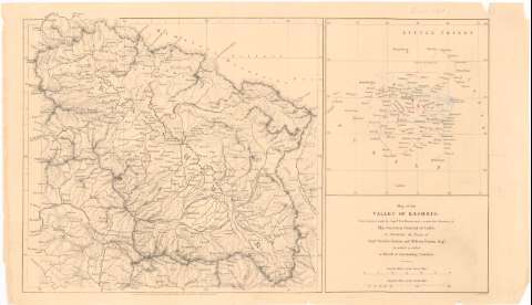
Map of the Valley of Kashmir


Section: Maps, plans and nautical charts
Uniform title: INDIA (Cachemira). Mapas generales. 1:700000 (1861)
Title: Map of the Valley of Kashmir / from Surveys made by Captn. T.G. Montgomerie under the direction y the Surveyor General of India ; to illustrate The Notes y Captn. Godwin Austen and William Purdon Esqr.
Material or type of resouce Area: Escala [ca. 1:700000], 30 english miles [= 6 cm] ; [proyec. conica] (E74°0'-75°30'/N30°25'-N33°30')
Publication: London : Puld. for The Journal of the Royal Geographical Socy. by J. Murray Albemarle Std., 1861
Physical description: 1 mapa ; 20x21,5 cm en h. de 22x38,5 cm
Content type: Imagen cartográfica
Media type: computadora
Carrier type: recurso en línea
Notes: Presenta además un mapa de detalle del Thibet
Escala grafica de 160 English miles [= 6 cm]. Red geografico de 1° en 1°
Relieve representado por normales
Notas manuscritas a lápiz al parecer de D. Francisco Coello
Other authors: Montgomerie, Thomas G
Austen, Godwin
Purdon, William
Murray, John
UDC: 912:551.43(540-328 Cachemir)'1861'
540-328 Cachemir
Type of publication:
 Maps
Maps
Rights:
Préstamo:
 Disponible
