Map of Richmond, Va. and Surrounding Country showing...


 Maps, plans and nautical charts
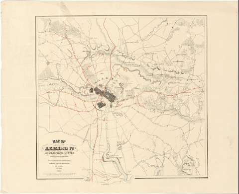
Map of Richmond, Va. and Surrounding Country showing Rebel Fortifications : From the latest and most authentic surveys (1864)
Maps, plans and nautical charts
Map of Richmond, Va. and Surrounding Country showing Rebel Fortifications : From the latest and most authentic surveys (1864)
 Disponible Holdings
 Section: Maps, plans and nautical charts
Title: Map of Richmond, Va. and Surrounding Country showing Rebel Fortifications : From the latest and most authentic surveys / Published by D. Van Nostrand ; J. Bien, Charles Sholl, T. E
Material or type of resouce Area: Escala indeterminada
Publication: New York : Published by Van Nostrand, 192 Broadway New York, 1864
Physical description: 1 mapa : col. ; 48 x 48 cm
Content type: Imagen cartográfica
Media type: computadora
Carrier type: recurso en línea
Notes: Presenta el plano de la población de Richmond y sus alrededores hasta aproximadamente nueve millas de distancia, indicando en color rojo la situación de las fortificaciones de los confederados, el radio de alcance defensivo de la ciudad y las líneas de ferrocarril
Orografía por normales
Materia / lugar / evento: Fortificaciones
Mapas topográficos
Planos de población
Líneas ferroviarias
1864
Virginia
Estados Unidos
Other authors: Bien, Julius, 1826-1909
Nostrand, D. Van
Sholl, Charles
UDC: 912:623.1:314(084.3):625.12(755)"1864"
755 Richmond
Type of publication:
Maps
Rights:
Préstamo:
Disponible
