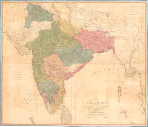
Map of Hindostan, or the Mogue Empire From the lateft...
Section: Maps, plans and nautical charts
Uniform title: India. Mapas generales. 1:3000000 (1788)
Title: Map of Hindostan, or the Mogue Empire From the lateft Authorities, A. : Inscribed to Sir Joseph Banks Bar. President of the Royal Society & C. & C.,... / J. Rennell ; Harmar Sculpt. 164, Picadilly ; the Map engravd by I. Phillips & W. Harrison ; the Writing by T. Harman
Material or type of resouce Area: Escala [ca. 1:3000000], 250 Britsh Miles, 69 1/2 to a degree ; [proyec. Cónica]
Publication: [London] : Publish'd according to Act of Parliament by James Renuell..., 1788
Physical description: 1 mapa : col., montado sobre tela ; 106,6x123,6 cm
Content type: Imagen cartográfica
Media type: computadora
Carrier type: recurso en línea
Notes: Escalas gráficas de 150 Cosses [= 13,5 cm] y 140 Carnatic Cosses [= 13,5 cm]. Coordenadas referidas a un meridiano que no se especifica (E63°30'-E101°30'/N32°00'-N5°10'). Red geográfica de 1° en 1°
Relieve de perfil
Indica veriles, bajos y sondas batimétricas
Entelado en 4 cuarterones
Other authors: Rennell, James, 1742-1830
Harmer, Thomas
Phillips, I
Harrison, W
UDC: 912:(540)'1788'
(548.7)
Type of publication:
![]() Maps
Maps
Préstamo:
![]() Disponible
Disponible


