Manila Bay


Section: Maps, plans and nautical charts
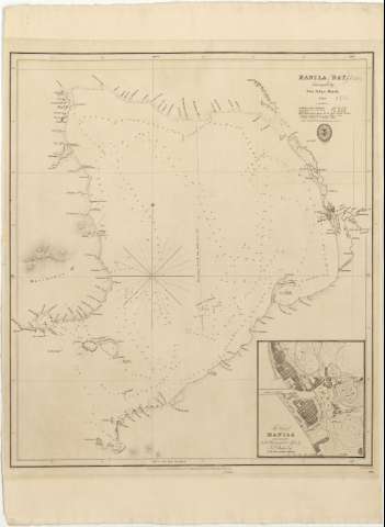
Title: Manila Bay / surveyed by Don Felipe Bauzá, 1792; J. and C. sculpt
Material or type of resouce Area: Escala [ca. 1:140000 ; proyec. Mercator] (E 119°26'38''--E 121°01'30''/N 14°50'45''--N 14°12'30'')
Publication: London : Published according to Act of Parliament at the Hydrographical Office of the Admiralty, by 25th. Jany. 1830
Physical description: 1 carta náutica ; 54 x 47 cm
Content type: Imagen cartográfica
Media type: computadora
Carrier type: recurso en línea
Notes: Escala calculada a partir de 1 minuto de latitud [= 1'3 cm]. Red geográfica de 10' en 10' para los paralelos y de 20' en 20' para los meridianos. Orientado con nudo de rumbos con estrella
Relieve representado mediante normales
Indica sondas batimétricas, veriles y calidad del fondo indicada por clave alfabética
Notas explictivas acerca de las latitudes y longitudes, la variación magnética, las mareas y las pesquerías
En el ángulo inferior derecho : "976"
Sello del "Hydrographical Office"
Inserta : "The City of Manila" / Communicated to the Hydrographical Office by J.P. Butler Esqr.- Escala [ca. 1:25000], 1 Geo Mile [= 7'3 cm]
Materia / lugar / evento: Cartas náuticas
Planos de población
Bahías
Mareas
Pesca
Islas
1792
Luzón (Isla)
Manila
Other authors: Bauzá, Felipe, 1764-1834
Butler, J.P
Gran Bretaña. Hydrographic Department
J. & C. Walker
UDC: 599 Manila, bahía
Type of publication:
 Maps
Maps
Rights:
Préstamo:
 Disponible
