Kriegs theater der teutschen und Franzoesischen...


 Maps, plans and nautical charts
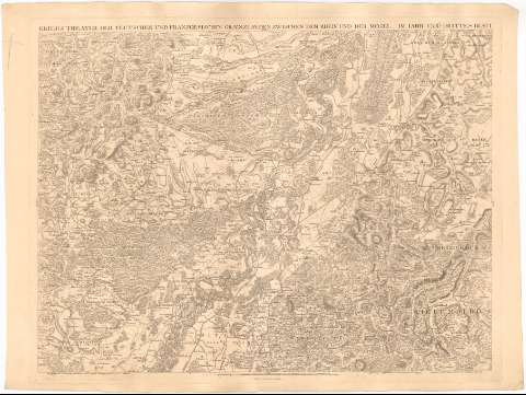
Kriegs theater der teutschen und Franzoesischen Graenzlanden Zwischen dem Rheim und der Mosel : im lahr 1794 Ertes... (1794)
Maps, plans and nautical charts
Kriegs theater der teutschen und Franzoesischen Graenzlanden Zwischen dem Rheim und der Mosel : im lahr 1794 Ertes... (1794)
 Disponible Holdings
 Section: Maps, plans and nautical charts
Title: Kriegs theater der teutschen und Franzoesischen Graenzlanden Zwischen dem Rheim und der Mosel : im lahr 1794 Ertes Blatt / Zuzamengesert v. C.P.G. Landum p Dewarcit ; gestochen von B.F. Leizelt
Material or type of resouce Area: Escala [ca. 1:88000], 10000 toises [= 22 cm]
Publication: Mannheim : Verlegt und zu Haben bey Dominic Artania, 1794
Physical description: 1 mapa ; 67,5x91,5 cm
Content type: Imagen cartográfica
Media type: computadora
Carrier type: recurso en línea
Notes: Escala gráfica de 2 'Stund Weges' [= 9,7 cm]. Orientado con los puntos cardinales
Relieve representado por normales y sombreado
Indica núcleos de población mediante edificios de perfil y masas forestales
Materia / lugar / evento: Mapas generales
1794
Baden-Württemberg
Other authors: Dewarat, Peter
Artaria, Domenico
Leizelt, B.F
UDC: 912(430-328 Renania Palatinado)'1794'
(430-328 Baden-Wurttemberg)
Type of publication:
Maps
Rights:
Préstamo:
Disponible
